Ban Phai geodata
Ban Phai (Khon Kaen) is a seat of a second-order administrative division; located in Thailand in Asia/Bangkok (GMT+7) time zone. With population of 35,583 people, there are 90 cities with bigger population in this country. Compared to other cities in Thailand, 66.5% of cities are located further ↓South; 76% of cities are located further ←West and 71.9% of cities have lower elevation than Ban Phai. Note1


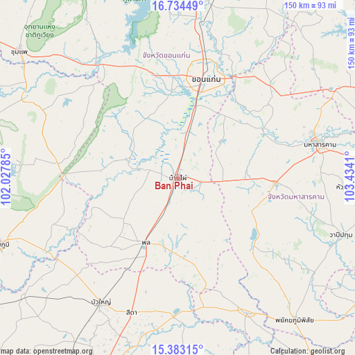
Ban Phai GPS coordinates[2]
16° 3' 35.892" North, 102° 43' 51.492" East
| Map corner | latitude | longitude |
|---|---|---|
| Upper-left | 16.73449°, | 102.02785° |
| Center: | 16.05997°, | 102.73097° |
| Lower-right: | 15.38315°, | 103.4341° |
| Map W x H: | 150.3×150.3 km | = 93.4×93.4mi |
| max Lat: | 20.43353° ⇑33.5% North |
| Ban Phai: | 16.05997° |
| min Lat: | ⇓66.5% South 5.77434° |
| min Long | Ban Phai | max Long |
| 97.93288° | 102.73097° | 105.49506° |
| W 76%⇐ | ⇒24% E |
Elevation
Elevation of Ban Phai is 174 m = 571 ft, and this is 48.5 m = 159 ft above average elevation for this country.
| Max E: |
1011 m = 3317 ft | 28.1% |
| Ban Phai | 174 m 571 ft | |
| Avg. | 125.5 m = 412 ft | |
Min E: |
1 m = 3 ft | 71.9% |
See also: Thailand elevation on elevation.city.
Geographical zone
Ban Phai is located in North Torrid zone (between Equator and Tropic of Cancer). Distance of this Northern Tropic circle is 820.2 km =509.6 mi to North.| Distance of | km | miles | from Ban Phai |
|---|---|---|---|
| North Pole | 8221.4 | 5108.5 | to North |
| Arctic Circle | 5615.5 | 3489.3 | to North |
| Tropic Cancer | 820.2 | 509.6 | to North |
| Equator | 1785.7 | 1109.6 | to South |


Nearby cities:
15 places around Ban Phai: (largest is in red/bold)
• Ban Haet
15.5 km =9.6 mi,  11°
11°
• Borabue
41.1 km =25.5 mi,  92°
92°
• Chonnabot
12.1 km =7.5 mi,  285°
285°
• Khok Pho Chai
35.6 km =22.1 mi,  274°
274°
• Khon Kaen
44.4 km =27.6 mi, 14°
• Kosum Phisai
41.6 km =25.8 mi,  59°
59°
• Kut Rang
30 km =18.6 mi,  82°
82°
• Mancha Khiri
22.1 km =13.7 mi, 290°
• Na Chueak
43.7 km =27.2 mi,  132°
132°
• Non Sila
11.5 km =7.1 mi,  214°
214°
• Phon
30.5 km =19 mi, 207°
• Phra Yuen
31.1 km =19.3 mi,  344°
344°
• Pueai Noi
28.4 km =17.6 mi,  138°
138°
• Waeng Noi
44.1 km =27.4 mi,  229°
229°
• Waeng Yai
22.8 km =14.2 mi,  239°
239°
Sources, notices
• [Note1] Compared only with cities in Thailand existing in our database
• [Src1] Map data: © OpenStreetMap contributors (CC-BY-SA)
• [Src2] Other city data from geonames.org with taken over terms of usage.
• [Src3] Geographical zone / Annual Mean Temperature by Robert A. Rohde @ Wikipedia
