Na Thawi geodata
Na Thawi (Songkhla) is a seat of a second-order administrative division; located in Thailand in Asia/Bangkok (GMT+7) time zone. In our database, there are 331 cities with bigger population. Compared to other cities in Thailand, 96.3% of cities are located further ↑North; 51.6% of cities are located further →East and 68.7% of cities have higher elevation than Na Thawi. Note1


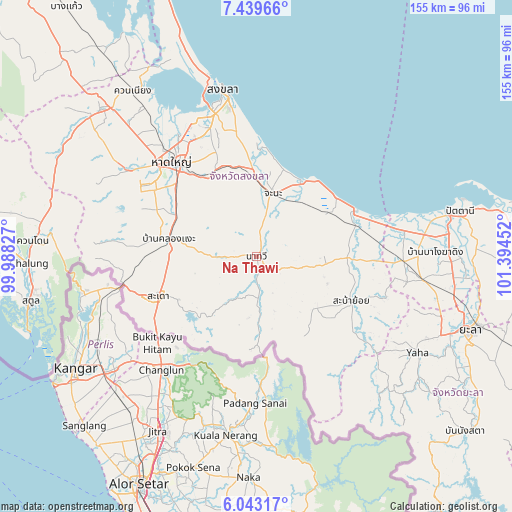
Na Thawi GPS coordinates[2]
6° 44' 30.912" North, 100° 41' 29.004" East
| Map corner | latitude | longitude |
|---|---|---|
| Upper-left | 7.43966°, | 99.98827° |
| Center: | 6.74192°, | 100.69139° |
| Lower-right: | 6.04317°, | 101.39452° |
| Map W x H: | 155.3×155.3 km | = 96.5×96.5mi |
| max Lat: | 20.43353° ⇑96.3% North |
| Na Thawi: | 6.74192° |
| min Lat: | ⇓3.7% South 5.77434° |
| min Long | Na Thawi | max Long |
| 97.93288° | 100.69139° | 105.49506° |
| W 48.4%⇐ | ⇒51.6% E |
Elevation
Elevation of Na Thawi is 25 m = 82 ft, and this is 100.5 m = 330 ft below average elevation for this country.
| Max E: |
1011 m = 3317 ft | 68.7% |
| Avg. | 125.5 m = 412 ft | |
| Na Thawi | 25 m = 82 ft | |
Min E: |
1 m = 3 ft | 31.3% |
See also: Thailand elevation on elevation.city.
Geographical zone
Na Thawi is located in North Torrid zone (between Equator and Tropic of Cancer). Distance of Equator is 749.6 km =465.8 mi to South.| Distance of | km | miles | from Na Thawi |
|---|---|---|---|
| North Pole | 9257.4 | 5752.3 | to North |
| Arctic Circle | 6651.5 | 4133 | to North |
| Tropic Cancer | 1856.3 | 1153.5 | to North |
| Equator | 749.6 | 465.8 | to South |


Nearby cities:
15 places around Na Thawi: (largest is in red/bold)
• Ban Mai
53.9 km =33.5 mi,  342°
342°
• Bang Klam
49.5 km =30.8 mi,  321°
321°
• Chana
20 km =12.4 mi,  15°
15°
• Hat Yai
37.9 km =23.5 mi, 321°
• Ka Bang
54.1 km =33.6 mi,  132°
132°
• Khlong Hoi Khong
37.7 km =23.4 mi,  297°
297°
• Khok Pho
44.7 km =27.8 mi,  91°
91°
• Na Mom
28.3 km =17.6 mi,  328°
328°
• Nong Chik
54.9 km =34.1 mi,  78°
78°
• Saba Yoi
31.9 km =19.8 mi,  115°
115°
• Sadao
31.7 km =19.7 mi,  248°
248°
• Singhanakhon
57.4 km =35.7 mi, 344°
• Songkhla
51.9 km =32.2 mi,  348°
348°
• Thepha
31.7 km =19.7 mi,  72°
72°
• Yaha
56.7 km =35.2 mi, 120°
Sources, notices
• [Note1] Compared only with cities in Thailand existing in our database
• [Src1] Map data: © OpenStreetMap contributors (CC-BY-SA)
• [Src2] Other city data from geonames.org with taken over terms of usage.
• [Src3] Geographical zone / Annual Mean Temperature by Robert A. Rohde @ Wikipedia
