Waeng Yai geodata
Waeng Yai (Khon Kaen) is a seat of a second-order administrative division; located in Thailand in Asia/Bangkok (GMT+7) time zone. In our database, there are 331 cities with bigger population. Compared to other cities in Thailand, 64.8% of cities are located further ↓South; 73.8% of cities are located further ←West and 78.8% of cities have lower elevation than Waeng Yai. Note1


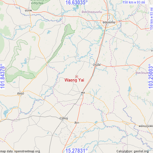
Waeng Yai GPS coordinates[2]
15° 57' 19.692" North, 102° 32' 48.84" East
| Map corner | latitude | longitude |
|---|---|---|
| Upper-left | 16.63035°, | 101.84378° |
| Center: | 15.95547°, | 102.5469° |
| Lower-right: | 15.27831°, | 103.25003° |
| Map W x H: | 150.3×150.3 km | = 93.4×93.4mi |
| max Lat: | 20.43353° ⇑35.2% North |
| Waeng Yai: | 15.95547° |
| min Lat: | ⇓64.8% South 5.77434° |
| min Long | Waeng Yai | max Long |
| 97.93288° | 102.5469° | 105.49506° |
| W 73.8%⇐ | ⇒26.2% E |
Elevation
Elevation of Waeng Yai is 193 m = 633 ft, and this is 67.5 m = 221 ft above average elevation for this country.
| Max E: |
1011 m = 3317 ft | 21.2% |
| Waeng Yai | 193 m 633 ft | |
| Avg. | 125.5 m = 412 ft | |
Min E: |
1 m = 3 ft | 78.8% |
See also: Thailand elevation on elevation.city.
Geographical zone
Waeng Yai is located in North Torrid zone (between Equator and Tropic of Cancer). Distance of this Northern Tropic circle is 831.8 km =516.9 mi to North.| Distance of | km | miles | from Waeng Yai |
|---|---|---|---|
| North Pole | 8233 | 5115.7 | to North |
| Arctic Circle | 5627.1 | 3496.5 | to North |
| Tropic Cancer | 831.8 | 516.9 | to North |
| Equator | 1774.1 | 1102.4 | to South |


Nearby cities:
15 places around Waeng Yai: (largest is in red/bold)
• Ban Haet
35.1 km =21.8 mi,  40°
40°
• Ban Phai
22.8 km =14.2 mi,  59°
59°
• Bua Lai
32.7 km =20.3 mi,  189°
189°
• Bua Yai
43.1 km =26.8 mi,  197°
197°
• Chonnabot
16.8 km =10.4 mi,  28°
28°
• Kaeng Khro
35.3 km =21.9 mi,  298°
298°
• Kaeng Sanam Nang
38.7 km =24 mi,  233°
233°
• Khok Pho Chai
21.3 km =13.2 mi,  312°
312°
• Khon Sawan
28.5 km =17.7 mi,  264°
264°
• Mancha Khiri
19.5 km =12.1 mi,  356°
356°
• Non Sila
13.3 km =8.3 mi,  80°
80°
• Phon
16.5 km =10.3 mi,  159°
159°
• Phra Yuen
43.1 km =26.8 mi,  15°
15°
• Pueai Noi
39.7 km =24.7 mi,  103°
103°
• Waeng Noi
21.9 km =13.6 mi,  219°
219°
Sources, notices
• [Note1] Compared only with cities in Thailand existing in our database
• [Src1] Map data: © OpenStreetMap contributors (CC-BY-SA)
• [Src2] Other city data from geonames.org with taken over terms of usage.
• [Src3] Geographical zone / Annual Mean Temperature by Robert A. Rohde @ Wikipedia
