Chaiyaphum geodata
Chaiyaphum is a seat of a first-order administrative division; located in Thailand in Asia/Bangkok (GMT+7) time zone. With population of 58,350 people, there are 41 cities with bigger population in this country. Compared to other cities in Thailand, 62.7% of cities are located further ↓South; 67% of cities are located further ←West and 77.2% of cities have lower elevation than Chaiyaphum. Note1


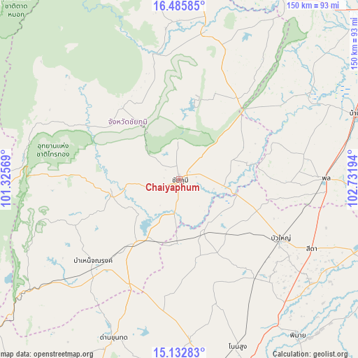
Chaiyaphum GPS coordinates[2]
15° 48' 37.692" North, 102° 1' 43.716" East
| Map corner | latitude | longitude |
|---|---|---|
| Upper-left | 16.48585°, | 101.32569° |
| Center: | 15.81047°, | 102.02881° |
| Lower-right: | 15.13283°, | 102.73194° |
| Map W x H: | 150.4×150.4 km | = 93.5×93.5mi |
| max Lat: | 20.43353° ⇑37.3% North |
| Chaiyaphum: | 15.81047° |
| min Lat: | ⇓62.7% South 5.77434° |
| min Long | Chaiyaphum | max Long |
| 97.93288° | 102.02881° | 105.49506° |
| W 67%⇐ | ⇒33% E |
Elevation
Elevation of Chaiyaphum is 188 m = 617 ft, and this is 62.5 m = 205 ft above average elevation for this country.
| Max E: |
1011 m = 3317 ft | 22.8% |
| Chaiyaphum | 188 m 617 ft | |
| Avg. | 125.5 m = 412 ft | |
Min E: |
1 m = 3 ft | 77.2% |
See also: Chaiyaphum elevation on elevation.city.
Geographical zone
Chaiyaphum is located in North Torrid zone (between Equator and Tropic of Cancer). Distance of this Northern Tropic circle is 848 km =526.9 mi to North.| Distance of | km | miles | from Chaiyaphum |
|---|---|---|---|
| North Pole | 8249.1 | 5125.8 | to North |
| Arctic Circle | 5643.2 | 3506.5 | to North |
| Tropic Cancer | 848 | 526.9 | to North |
| Equator | 1758 | 1092.4 | to South |


Nearby cities:
15 places around Chaiyaphum: (largest is in red/bold)
• Bamnet Narong
49.9 km =31 mi,  226°
226°
• Ban Khwao
13.5 km =8.4 mi,  254°
254°
• Ban Lueam
24.8 km =15.4 mi,  154°
154°
• Bua Yai
49.3 km =30.6 mi,  120°
120°
• Chatturat
33.6 km =20.9 mi,  215°
215°
• Kaeng Khro
41.2 km =25.6 mi,  36°
36°
• Kaeng Sanam Nang
25.1 km =15.6 mi,  105°
105°
• Khok Pho Chai
49.9 km =31 mi,  52°
52°
• Khon Sawan
30.2 km =18.8 mi,  63°
63°
• Khong
51.9 km =32.2 mi,  141°
141°
• Noen Sa-nga
27.5 km =17.1 mi,  186°
186°
• Nong Bua Daeng
38.5 km =23.9 mi,  321°
321°
• Nong Bua Rawe
29 km =18 mi,  257°
257°
• Sap Yai
48.1 km =29.9 mi, 246°
• Waeng Noi
41.4 km =25.7 mi,  91°
91°
Sources, notices
• [Note1] Compared only with cities in Thailand existing in our database
• [Src1] Map data: © OpenStreetMap contributors (CC-BY-SA)
• [Src2] Other city data from geonames.org with taken over terms of usage.
• [Src3] Geographical zone / Annual Mean Temperature by Robert A. Rohde @ Wikipedia
