Chom Phra geodata
Chom Phra (Surin) is a seat of a second-order administrative division; located in Thailand in Asia/Bangkok (GMT+7) time zone. In our database, there are 331 cities with bigger population. Compared to other cities in Thailand, 51.9% of cities are located further ↓South; 86% of cities are located further ←West and 56.9% of cities have lower elevation than Chom Phra. Note1


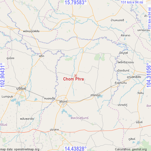
Chom Phra GPS coordinates[2]
15° 7' 5.304" North, 103° 36' 26.748" East
| Map corner | latitude | longitude |
|---|---|---|
| Upper-left | 15.79583°, | 102.90431° |
| Center: | 15.11814°, | 103.60743° |
| Lower-right: | 14.43828°, | 104.31056° |
| Map W x H: | 150.9×150.9 km | = 93.8×93.8mi |
| max Lat: | 20.43353° ⇑48.1% North |
| Chom Phra: | 15.11814° |
| min Lat: | ⇓51.9% South 5.77434° |
| min Long | Chom Phra | max Long |
| 97.93288° | 103.60743° | 105.49506° |
| W 86%⇐ | ⇒14% E |
Elevation
Elevation of Chom Phra is 141 m = 463 ft, and this is 15.5 m = 51 ft above average elevation for this country.
| Max E: |
1011 m = 3317 ft | 43.1% |
| Chom Phra | 141 m 463 ft | |
| Avg. | 125.5 m = 412 ft | |
Min E: |
1 m = 3 ft | 56.9% |
See also: Thailand elevation on elevation.city.
Geographical zone
Chom Phra is located in North Torrid zone (between Equator and Tropic of Cancer). Distance of this Northern Tropic circle is 924.9 km =574.7 mi to North.| Distance of | km | miles | from Chom Phra |
|---|---|---|---|
| North Pole | 8326.1 | 5173.6 | to North |
| Arctic Circle | 5720.2 | 3554.4 | to North |
| Tropic Cancer | 924.9 | 574.7 | to North |
| Equator | 1681 | 1044.5 | to South |


Nearby cities:
15 places around Chom Phra: (largest is in red/bold)
• Ban Dan
46.4 km =28.8 mi,  268°
268°
• Chumphon Buri
34.5 km =21.4 mi,  317°
317°
• Huai Thap Than
45.7 km =28.4 mi,  99°
99°
• Khwao Sinarin
13 km =8.1 mi,  187°
187°
• Krasang
39.1 km =24.3 mi,  236°
236°
• Lamduan
44.5 km =27.7 mi,  171°
171°
• Mueang Chan
46.2 km =28.7 mi,  84°
84°
• Non Narai
35.4 km =22 mi,  67°
67°
• Rattanaburi
34.1 km =21.2 mi,  49°
49°
• Samrong Thap
36.9 km =22.9 mi,  106°
106°
• Sanom
19 km =11.8 mi,  59°
59°
• Satuek
39.3 km =24.4 mi,  300°
300°
• Si Khoraphum
28.1 km =17.5 mi,  133°
133°
• Surin
29 km =18 mi,  204°
204°
• Tha Tum
23.5 km =14.6 mi,  18°
18°
Sources, notices
• [Note1] Compared only with cities in Thailand existing in our database
• [Src1] Map data: © OpenStreetMap contributors (CC-BY-SA)
• [Src2] Other city data from geonames.org with taken over terms of usage.
• [Src3] Geographical zone / Annual Mean Temperature by Robert A. Rohde @ Wikipedia
