Chumphon Buri geodata
Chumphon Buri (Surin) is a seat of a second-order administrative division; located in Thailand in Asia/Bangkok (GMT+7) time zone. In our database, there are 331 cities with bigger population. Compared to other cities in Thailand, 56% of cities are located further ↓South; 83.8% of cities are located further ←West and 53.9% of cities have lower elevation than Chumphon Buri. Note1


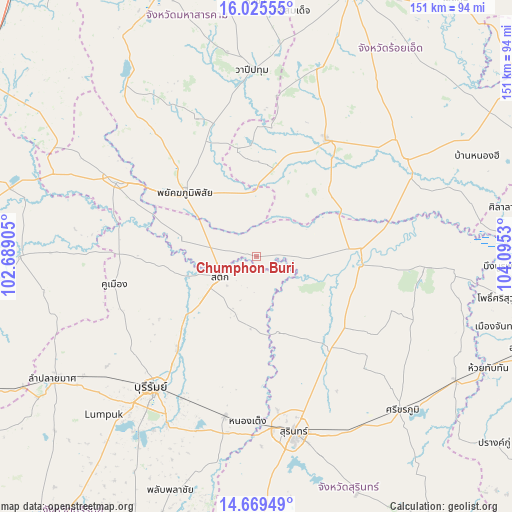
Chumphon Buri GPS coordinates[2]
15° 20' 55.032" North, 103° 23' 31.812" East
| Map corner | latitude | longitude |
|---|---|---|
| Upper-left | 16.02555°, | 102.68905° |
| Center: | 15.34862°, | 103.39217° |
| Lower-right: | 14.66949°, | 104.0953° |
| Map W x H: | 150.8×150.8 km | = 93.7×93.7mi |
| max Lat: | 20.43353° ⇑44% North |
| Chumphon Buri: | 15.34862° |
| min Lat: | ⇓56% South 5.77434° |
| min Long | Chumphon Buri | max Long |
| 97.93288° | 103.39217° | 105.49506° |
| W 83.8%⇐ | ⇒16.2% E |
Elevation
Elevation of Chumphon Buri is 133 m = 436 ft, and this is 7.5 m = 25 ft above average elevation for this country.
| Max E: |
1011 m = 3317 ft | 46.1% |
| Chumphon Buri | 133 m 436 ft | |
| Avg. | 125.5 m = 412 ft | |
Min E: |
1 m = 3 ft | 53.9% |
See also: Thailand elevation on elevation.city.
Geographical zone
Chumphon Buri is located in North Torrid zone (between Equator and Tropic of Cancer). Distance of this Northern Tropic circle is 899.3 km =558.8 mi to North.| Distance of | km | miles | from Chumphon Buri |
|---|---|---|---|
| North Pole | 8300.5 | 5157.7 | to North |
| Arctic Circle | 5694.6 | 3538.5 | to North |
| Tropic Cancer | 899.3 | 558.8 | to North |
| Equator | 1706.6 | 1060.4 | to South |


Nearby cities:
15 places around Chumphon Buri: (largest is in red/bold)
• Ban Dan
35.4 km =22 mi,  221°
221°
• Chom Phra
34.5 km =21.4 mi,  137°
137°
• Huai Rat
48.4 km =30.1 mi,  206°
206°
• Kaset Wisai
39.8 km =24.7 mi,  31°
31°
• Khaen Dong
27.9 km =17.3 mi,  264°
264°
• Khu Mueang
42.7 km =26.5 mi, 258°
• Khwao Sinarin
44 km =27.3 mi,  150°
150°
• Krasang
48.2 km =30 mi,  191°
191°
• Na Dun
44.6 km =27.7 mi,  336°
336°
• Pathum Rat
32.2 km =20 mi,  350°
350°
• Phayakkhaphum Phisai
28.3 km =17.6 mi,  311°
311°
• Phutthaisong
45.2 km =28.1 mi,  299°
299°
• Sanom
42.7 km =26.5 mi,  112°
112°
• Satuek
12.2 km =7.6 mi,  241°
241°
• Tha Tum
30.5 km =19 mi,  96°
96°
Sources, notices
• [Note1] Compared only with cities in Thailand existing in our database
• [Src1] Map data: © OpenStreetMap contributors (CC-BY-SA)
• [Src2] Other city data from geonames.org with taken over terms of usage.
• [Src3] Geographical zone / Annual Mean Temperature by Robert A. Rohde @ Wikipedia
