Touza geodata
Touza (Al Munastīr) is a populated place; located in Tunisia in Africa/Tunis (GMT+1) time zone. With population of 6,085 people, there are 111 cities with bigger population in this country. Compared to other cities in Tunisia, 62.2% of cities are located further ↑North; 83.2% of cities are located further ←West and 57.3% of cities have higher elevation than Touza. Note1


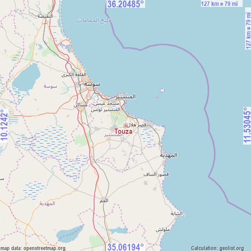
Touza GPS coordinates[2]
35° 38' 7.584" North, 10° 49' 38.352" East
| Map corner | latitude | longitude |
|---|---|---|
| Upper-left | 36.20485°, | 10.1242° |
| Center: | 35.63544°, | 10.82732° |
| Lower-right: | 35.06194°, | 11.53045° |
| Map W x H: | 127.1×127.1 km | = 79×79mi |
| max Lat: | 37.27442° ⇑62.2% North |
| Touza: | 35.63544° |
| min Lat: | ⇓37.8% South 32.31662° |
| min Long | Touza | max Long |
| 7.87765° | 10.82732° | 11.21965° |
| W 83.2%⇐ | ⇒16.8% E |
Elevation
Elevation of Touza is 35 m = 115 ft, and this is 114.4 m = 375 ft below average elevation for this country.
| Max E: |
999 m = 3278 ft | 57.3% |
| Avg. | 149.4 m = 490 ft | |
| Touza | 35 m = 115 ft | |
Min E: |
-6 m = -20 ft | 42.7% |
See also: Tunisia elevation on elevation.city.
Geographical zone
Touza is located in North temperate zone (between Tropic of Cancer and the Arctic Circle). Distance of this Northern Tropic circle is 1356.4 km =842.8 mi to South.| Distance of | km | miles | from Touza |
|---|---|---|---|
| North Pole | 6044.8 | 3756.1 | to North |
| Arctic Circle | 3438.9 | 2136.8 | to North |
| Tropic Cancer | 1356.4 | 842.8 | to South |
| Equator | 3962.3 | 2462.1 | to South |


Nearby cities:
15 places around Touza: (largest is in red/bold)
• Banbalah
7.6 km =4.7 mi,  341°
341°
• Bekalta
15.3 km =9.5 mi,  97°
97°
• Beni Hassane
7.8 km =4.8 mi,  192°
192°
• Djemmal
6.5 km =4 mi,  257°
257°
• Ksar Hellal
5.9 km =3.7 mi,  76°
76°
• Ksibet el Mediouni
5.7 km =3.5 mi,  13°
13°
• Lemta
6.1 km =3.8 mi,  55°
55°
• Menzel Kamel
14.5 km =9 mi,  265°
265°
• Mesdour
10.4 km =6.5 mi,  299°
299°
• Monastir
15.9 km =9.9 mi,  359°
359°
• Ouardenine
16.1 km =10 mi, 300°
• Sahline
16.6 km =10.3 mi,  320°
320°
• Seïada
7 km =4.3 mi, 57°
• Sidi Ben Nour
13.9 km =8.6 mi,  144°
144°
• Skanes
16.6 km =10.3 mi,  351°
351°
Sources, notices
• [Note1] Compared only with cities in Tunisia existing in our database
• [Src1] Map data: © OpenStreetMap contributors (CC-BY-SA)
• [Src2] Other city data from geonames.org with taken over terms of usage.
• [Src3] Geographical zone / Annual Mean Temperature by Robert A. Rohde @ Wikipedia
