Djemmal geodata
Djemmal (Al Munastīr) is a populated place; located in Tunisia in Africa/Tunis (GMT+1) time zone. With population of 39,990 people, there are 36 cities with bigger population in this country. Compared to other cities in Tunisia, 64.3% of cities are located further ↑North; 76.9% of cities are located further ←West and 61.5% of cities have higher elevation than Djemmal. Note1


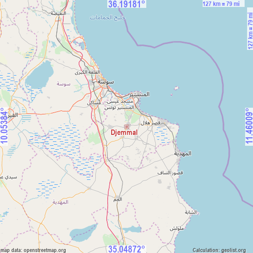
Djemmal GPS coordinates[2]
35° 37' 20.316" North, 10° 45' 25.056" East
| Map corner | latitude | longitude |
|---|---|---|
| Upper-left | 36.19181°, | 10.05384° |
| Center: | 35.62231°, | 10.75696° |
| Lower-right: | 35.04872°, | 11.46009° |
| Map W x H: | 127.1×127.1 km | = 79×79mi |
| max Lat: | 37.27442° ⇑64.3% North |
| Djemmal: | 35.62231° |
| min Lat: | ⇓35.7% South 32.31662° |
| min Long | Djemmal | max Long |
| 7.87765° | 10.75696° | 11.21965° |
| W 76.9%⇐ | ⇒23.1% E |
Elevation
Elevation of Djemmal is 30 m = 98 ft, and this is 119.4 m = 392 ft below average elevation for this country.
| Max E: |
999 m = 3278 ft | 61.5% |
| Avg. | 149.4 m = 490 ft | |
| Djemmal | 30 m = 98 ft | |
Min E: |
-6 m = -20 ft | 38.5% |
See also: Tunisia elevation on elevation.city.
Geographical zone
Djemmal is located in North temperate zone (between Tropic of Cancer and the Arctic Circle). Distance of this Northern Tropic circle is 1354.9 km =841.9 mi to South.| Distance of | km | miles | from Djemmal |
|---|---|---|---|
| North Pole | 6046.2 | 3756.9 | to North |
| Arctic Circle | 3440.3 | 2137.7 | to North |
| Tropic Cancer | 1354.9 | 841.9 | to South |
| Equator | 3960.8 | 2461.1 | to South |


Nearby cities:
15 places around Djemmal: (largest is in red/bold)
• Banbalah
9.5 km =5.9 mi,  24°
24°
• Beni Hassane
7.7 km =4.8 mi,  142°
142°
• Ksar Hellal
12.4 km =7.7 mi,  76°
76°
• Ksibet el Mediouni
10.5 km =6.5 mi,  47°
47°
• Lemta
12.4 km =7.7 mi,  66°
66°
• Menzel Kamel
8.1 km =5 mi,  271°
271°
• Mesdour
7.2 km =4.5 mi,  338°
338°
• Monastir
18.4 km =11.4 mi, 19°
• Msaken
19.9 km =12.4 mi,  306°
306°
• Ouardenine
12.2 km =7.6 mi,  322°
322°
• Sahline
15 km =9.3 mi, 343°
• Seïada
13.3 km =8.3 mi, 67°
• Sidi Ben Nour
17.5 km =10.9 mi,  124°
124°
• Skanes
18.3 km =11.4 mi,  12°
12°
• Touza
6.5 km =4 mi, 77°
Sources, notices
• [Note1] Compared only with cities in Tunisia existing in our database
• [Src1] Map data: © OpenStreetMap contributors (CC-BY-SA)
• [Src2] Other city data from geonames.org with taken over terms of usage.
• [Src3] Geographical zone / Annual Mean Temperature by Robert A. Rohde @ Wikipedia
