Mesdour geodata
Mesdour (Al Munastīr) is a populated place; located in Tunisia in Africa/Tunis (GMT+1) time zone. With population of 3,372 people, there are 133 cities with bigger population in this country. Compared to other cities in Tunisia, 57.3% of cities are located further ↑North; 74.1% of cities are located further ←West and 69.2% of cities have higher elevation than Mesdour. Note1


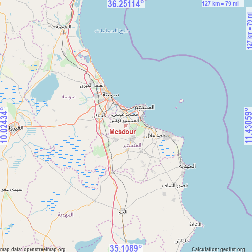
Mesdour GPS coordinates[2]
35° 40' 55.416" North, 10° 43' 38.856" East
| Map corner | latitude | longitude |
|---|---|---|
| Upper-left | 36.25114°, | 10.02434° |
| Center: | 35.68206°, | 10.72746° |
| Lower-right: | 35.1089°, | 11.43059° |
| Map W x H: | 127×127 km | = 78.9×78.9mi |
| max Lat: | 37.27442° ⇑57.3% North |
| Mesdour: | 35.68206° |
| min Lat: | ⇓42.7% South 32.31662° |
| min Long | Mesdour | max Long |
| 7.87765° | 10.72746° | 11.21965° |
| W 74.1%⇐ | ⇒25.9% E |
Elevation
Elevation of Mesdour is 21 m = 69 ft, and this is 128.4 m = 421 ft below average elevation for this country.
| Max E: |
999 m = 3278 ft | 69.2% |
| Avg. | 149.4 m = 490 ft | |
| Mesdour | 21 m = 69 ft | |
Min E: |
-6 m = -20 ft | 30.8% |
See also: Tunisia elevation on elevation.city.
Geographical zone
Mesdour is located in North temperate zone (between Tropic of Cancer and the Arctic Circle). Distance of this Northern Tropic circle is 1361.6 km =846.1 mi to South.| Distance of | km | miles | from Mesdour |
|---|---|---|---|
| North Pole | 6039.6 | 3752.8 | to North |
| Arctic Circle | 3433.7 | 2133.6 | to North |
| Tropic Cancer | 1361.6 | 846.1 | to South |
| Equator | 3967.5 | 2465.3 | to South |


Nearby cities:
15 places around Mesdour: (largest is in red/bold)
• Banbalah
6.8 km =4.2 mi,  73°
73°
• Beni Hassane
14.7 km =9.1 mi,  150°
150°
• Djemmal
7.2 km =4.5 mi,  158°
158°
• Ksar Hellal
15.2 km =9.4 mi,  104°
104°
• Ksibet el Mediouni
10.4 km =6.5 mi,  87°
87°
• Lemta
14.2 km =8.8 mi, 96°
• Menzel Kamel
8.4 km =5.2 mi,  220°
220°
• Monastir
13.9 km =8.6 mi,  39°
39°
• Msaken
14.2 km =8.8 mi,  291°
291°
• Ouardenine
5.7 km =3.5 mi,  301°
301°
• Sahline
7.9 km =4.9 mi,  349°
349°
• Seïada
15 km =9.3 mi, 95°
• Skanes
13 km =8.1 mi,  30°
30°
• Sousse
17.9 km =11.1 mi,  332°
332°
• Touza
10.4 km =6.5 mi,  119°
119°
Sources, notices
• [Note1] Compared only with cities in Tunisia existing in our database
• [Src1] Map data: © OpenStreetMap contributors (CC-BY-SA)
• [Src2] Other city data from geonames.org with taken over terms of usage.
• [Src3] Geographical zone / Annual Mean Temperature by Robert A. Rohde @ Wikipedia
