Seïada geodata
Seïada (Al Munastīr) is a populated place; located in Tunisia in Africa/Tunis (GMT+1) time zone. With population of 13,718 people, there are 75 cities with bigger population in this country. Compared to other cities in Tunisia, 59.4% of cities are located further ↑North; 88.8% of cities are located further ←West and 78.3% of cities have higher elevation than Seïada. Note1


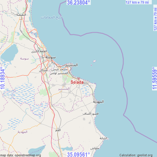
Seïada GPS coordinates[2]
35° 40' 7.932" North, 10° 53' 32.856" East
| Map corner | latitude | longitude |
|---|---|---|
| Upper-left | 36.23804°, | 10.18934° |
| Center: | 35.66887°, | 10.89246° |
| Lower-right: | 35.09561°, | 11.59559° |
| Map W x H: | 127×127 km | = 78.9×78.9mi |
| max Lat: | 37.27442° ⇑59.4% North |
| Seïada: | 35.66887° |
| min Lat: | ⇓40.6% South 32.31662° |
| min Long | Seïada | max Long |
| 7.87765° | 10.89246° | 11.21965° |
| W 88.8%⇐ | ⇒11.2% E |
Elevation
Elevation of Seïada is 13 m = 43 ft, and this is 136.4 m = 448 ft below average elevation for this country.
| Max E: |
999 m = 3278 ft | 78.3% |
| Avg. | 149.4 m = 490 ft | |
| Seïada | 13 m = 43 ft | |
Min E: |
-6 m = -20 ft | 21.7% |
See also: Tunisia elevation on elevation.city.
Geographical zone
Seïada is located in North temperate zone (between Tropic of Cancer and the Arctic Circle). Distance of this Northern Tropic circle is 1360.1 km =845.1 mi to South.| Distance of | km | miles | from Seïada |
|---|---|---|---|
| North Pole | 6041.1 | 3753.8 | to North |
| Arctic Circle | 3435.2 | 2134.5 | to North |
| Tropic Cancer | 1360.1 | 845.1 | to South |
| Equator | 3966 | 2464.4 | to South |


Nearby cities:
15 places around Seïada: (largest is in red/bold)
• Banbalah
9 km =5.6 mi,  292°
292°
• Bekalta
10.9 km =6.8 mi,  121°
121°
• Beni Hassane
13.6 km =8.5 mi,  213°
213°
• Djemmal
13.3 km =8.3 mi,  247°
247°
• Ksar Hellal
2.4 km =1.5 mi,  184°
184°
• Ksibet el Mediouni
4.9 km =3 mi, 292°
• Lemta
0.9 km =0.6 mi, 253°
• Menzel Kamel
20.9 km =13 mi,  256°
256°
• Mesdour
15 km =9.3 mi,  275°
275°
• Monastir
13.5 km =8.4 mi,  333°
333°
• Ouardenine
20.2 km =12.6 mi, 282°
• Sahline
18.8 km =11.7 mi,  299°
299°
• Sidi Ben Nour
15.2 km =9.4 mi,  171°
171°
• Skanes
15.2 km =9.4 mi, 326°
• Touza
7 km =4.3 mi,  237°
237°
Sources, notices
• [Note1] Compared only with cities in Tunisia existing in our database
• [Src1] Map data: © OpenStreetMap contributors (CC-BY-SA)
• [Src2] Other city data from geonames.org with taken over terms of usage.
• [Src3] Geographical zone / Annual Mean Temperature by Robert A. Rohde @ Wikipedia
