Banbalah geodata
Banbalah (Al Munastīr) is a populated place; located in Tunisia in Africa/Tunis (GMT+1) time zone. With population of 12,367 people, there are 80 cities with bigger population in this country. Compared to other cities in Tunisia, 55.9% of cities are located further ↑North; 79.7% of cities are located further ←West and 70.6% of cities have higher elevation than Banbalah. Note1


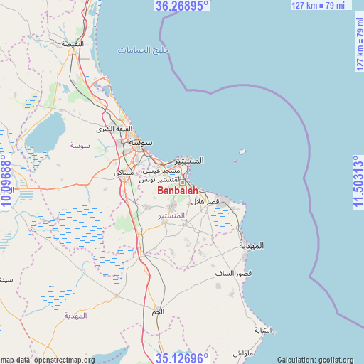
Banbalah GPS coordinates[2]
35° 42' 0" North, 10° 48' 0" East
| Map corner | latitude | longitude |
|---|---|---|
| Upper-left | 36.26895°, | 10.09688° |
| Center: | 35.7°, | 10.8° |
| Lower-right: | 35.12696°, | 11.50313° |
| Map W x H: | 127×127 km | = 78.9×78.9mi |
| max Lat: | 37.27442° ⇑55.9% North |
| Banbalah: | 35.7° |
| min Lat: | ⇓44.1% South 32.31662° |
| min Long | Banbalah | max Long |
| 7.87765° | 10.8° | 11.21965° |
| W 79.7%⇐ | ⇒20.3% E |
Elevation
Elevation of Banbalah is 20 m = 66 ft, and this is 129.4 m = 425 ft below average elevation for this country.
| Max E: |
999 m = 3278 ft | 70.6% |
| Avg. | 149.4 m = 490 ft | |
| Banbalah | 20 m = 66 ft | |
Min E: |
-6 m = -20 ft | 29.4% |
See also: Tunisia elevation on elevation.city.
Geographical zone
Banbalah is located in North temperate zone (between Tropic of Cancer and the Arctic Circle). Distance of this Northern Tropic circle is 1363.5 km =847.2 mi to South.| Distance of | km | miles | from Banbalah |
|---|---|---|---|
| North Pole | 6037.6 | 3751.6 | to North |
| Arctic Circle | 3431.7 | 2132.4 | to North |
| Tropic Cancer | 1363.5 | 847.2 | to South |
| Equator | 3969.5 | 2466.5 | to South |


Nearby cities:
15 places around Banbalah: (largest is in red/bold)
• Bekalta
19.8 km =12.3 mi,  117°
117°
• Beni Hassane
14.8 km =9.2 mi,  176°
176°
• Djemmal
9.5 km =5.9 mi,  204°
204°
• Ksar Hellal
10 km =6.2 mi,  125°
125°
• Ksibet el Mediouni
4.2 km =2.6 mi,  112°
112°
• Lemta
8.4 km =5.2 mi, 116°
• Menzel Kamel
14.6 km =9.1 mi,  235°
235°
• Mesdour
6.8 km =4.2 mi,  253°
253°
• Monastir
9 km =5.6 mi,  15°
15°
• Msaken
20.1 km =12.5 mi,  279°
279°
• Ouardenine
11.4 km =7.1 mi, 275°
• Sahline
9.9 km =6.2 mi,  305°
305°
• Seïada
9 km =5.6 mi, 112°
• Skanes
9.3 km =5.8 mi,  0°
0°
• Touza
7.6 km =4.7 mi,  161°
161°
Sources, notices
• [Note1] Compared only with cities in Tunisia existing in our database
• [Src1] Map data: © OpenStreetMap contributors (CC-BY-SA)
• [Src2] Other city data from geonames.org with taken over terms of usage.
• [Src3] Geographical zone / Annual Mean Temperature by Robert A. Rohde @ Wikipedia
