Korbous geodata
Korbous (Nābul) is a populated place; located in Tunisia in Africa/Tunis (GMT+1) time zone. With population of 3,581 people, there are 130 cities with bigger population in this country. Compared to other cities in Tunisia, 83.9% of cities are located further ↓South; 64.3% of cities are located further ←West and 73.4% of cities have higher elevation than Korbous. Note1


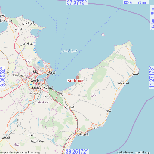
Korbous GPS coordinates[2]
36° 49' 0.048" North, 10° 34' 7.14" East
| Map corner | latitude | longitude |
|---|---|---|
| Upper-left | 37.3775°, | 9.86552° |
| Center: | 36.81668°, | 10.56865° |
| Lower-right: | 36.25172°, | 11.27178° |
| Map W x H: | 125.2×125.2 km | = 77.8×77.8mi |
| max Lat: | 37.27442° ⇑16.1% North |
| Korbous: | 36.81668° |
| min Lat: | ⇓83.9% South 32.31662° |
| min Long | Korbous | max Long |
| 7.87765° | 10.56865° | 11.21965° |
| W 64.3%⇐ | ⇒35.7% E |
Elevation
Elevation of Korbous is 16 m = 52 ft, and this is 133.4 m = 438 ft below average elevation for this country.
| Max E: |
999 m = 3278 ft | 73.4% |
| Avg. | 149.4 m = 490 ft | |
| Korbous | 16 m = 52 ft | |
Min E: |
-6 m = -20 ft | 26.6% |
See also: Tunisia elevation on elevation.city.
Geographical zone
Korbous is located in North temperate zone (between Tropic of Cancer and the Arctic Circle). Distance of this Northern Tropic circle is 1487.7 km =924.4 mi to South.| Distance of | km | miles | from Korbous |
|---|---|---|---|
| North Pole | 5913.4 | 3674.4 | to North |
| Arctic Circle | 3307.5 | 2055.2 | to North |
| Tropic Cancer | 1487.7 | 924.4 | to South |
| Equator | 4093.6 | 2543.6 | to South |


Nearby cities:
15 places around Korbous: (largest is in red/bold)
• Al Marsá
22.8 km =14.2 mi,  287°
287°
• Ariana
33.7 km =20.9 mi,  278°
278°
• Ben Arous
31.7 km =19.7 mi,  257°
257°
• Beni Khalled
18.6 km =11.6 mi,  174°
174°
• Bou Arkoub
31 km =19.3 mi,  182°
182°
• Carthage
21.7 km =13.5 mi, 283°
• El Mida
27.5 km =17.1 mi,  111°
111°
• Hammam-Lif
22.5 km =14 mi,  244°
244°
• La Goulette
23.5 km =14.6 mi,  270°
270°
• La Sebala du Mornag
29 km =18 mi, 238°
• Mennzel Bou Zelfa
14.9 km =9.3 mi, 174°
• Radès
26.7 km =16.6 mi, 258°
• Sidi Bou Saïd
21 km =13 mi, 285°
• Takelsa
6.8 km =4.2 mi,  122°
122°
• Zaouiat Djedidi
19.2 km =11.9 mi, 178°
Sources, notices
• [Note1] Compared only with cities in Tunisia existing in our database
• [Src1] Map data: © OpenStreetMap contributors (CC-BY-SA)
• [Src2] Other city data from geonames.org with taken over terms of usage.
• [Src3] Geographical zone / Annual Mean Temperature by Robert A. Rohde @ Wikipedia
