Al Marsá geodata
Al Marsá (Tūnis) is a seat of a second-order administrative division; located in Tunisia in Africa/Tunis (GMT+1) time zone. With population of 65,640 people, there are 14 cities with bigger population in this country. Compared to other cities in Tunisia, 89.5% of cities are located further ↓South; 55.9% of cities are located further ←West and 79% of cities have higher elevation than Al Marsá. Note1


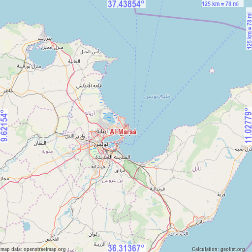
Al Marsá GPS coordinates[2]
36° 52' 41.448" North, 10° 19' 28.776" East
| Map corner | latitude | longitude |
|---|---|---|
| Upper-left | 37.43854°, | 9.62154° |
| Center: | 36.87818°, | 10.32466° |
| Lower-right: | 36.31367°, | 11.02779° |
| Map W x H: | 125.1×125.1 km | = 77.7×77.7mi |
| max Lat: | 37.27442° ⇑10.5% North |
| Al Marsá: | 36.87818° |
| min Lat: | ⇓89.5% South 32.31662° |
| min Long | Al Marsá | max Long |
| 7.87765° | 10.32466° | 11.21965° |
| W 55.9%⇐ | ⇒44.1% E |
Elevation
Elevation of Al Marsá is 12 m = 39 ft, and this is 137.4 m = 451 ft below average elevation for this country.
| Max E: |
999 m = 3278 ft | 79% |
| Avg. | 149.4 m = 490 ft | |
| Al Marsá | 12 m = 39 ft | |
Min E: |
-6 m = -20 ft | 21% |
See also: Al Marsá elevation on elevation.city.
Geographical zone
Al Marsá is located in North temperate zone (between Tropic of Cancer and the Arctic Circle). Distance of this Northern Tropic circle is 1494.6 km =928.7 mi to South.| Distance of | km | miles | from Al Marsá |
|---|---|---|---|
| North Pole | 5906.6 | 3670.2 | to North |
| Arctic Circle | 3300.7 | 2051 | to North |
| Tropic Cancer | 1494.6 | 928.7 | to South |
| Equator | 4100.5 | 2547.9 | to South |


Nearby cities:
15 places around Al Marsá: (largest is in red/bold)
• Ariana
11.8 km =7.3 mi,  260°
260°
• Ben Arous
16.5 km =10.3 mi,  213°
213°
• Carthage
2 km =1.2 mi,  161°
161°
• Galaat el Andeless
27.5 km =17.1 mi,  318°
318°
• Hammam-Lif
16.7 km =10.4 mi,  174°
174°
• Korbous
22.8 km =14.2 mi,  107°
107°
• La Goulette
6.9 km =4.3 mi,  194°
194°
• La Mohammedia
27.2 km =16.9 mi, 213°
• La Sebala du Mornag
22.3 km =13.9 mi, 187°
• Manouba
21.7 km =13.5 mi,  249°
249°
• Oued Lill
25.7 km =16 mi, 259°
• Radès
12.9 km =8 mi,  200°
200°
• Sidi Bou Saïd
1.8 km =1.1 mi,  124°
124°
• Takelsa
29.4 km =18.3 mi, 111°
• Tunis
15.6 km =9.7 mi, 245°
Sources, notices
• [Note1] Compared only with cities in Tunisia existing in our database
• [Src1] Map data: © OpenStreetMap contributors (CC-BY-SA)
• [Src2] Other city data from geonames.org with taken over terms of usage.
• [Src3] Geographical zone / Annual Mean Temperature by Robert A. Rohde @ Wikipedia
