Hammam-Lif geodata
Hammam-Lif (Bin ‘Arūs) is a populated place; located in Tunisia in Africa/Tunis (GMT+1) time zone. With population of 47,760 people, there are 27 cities with bigger population in this country. Compared to other cities in Tunisia, 79.7% of cities are located further ↓South; 57.3% of cities are located further ←West and 97.9% of cities have higher elevation than Hammam-Lif. Note1


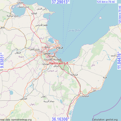
Hammam-Lif GPS coordinates[2]
36° 43' 43.176" North, 10° 20' 29.868" East
| Map corner | latitude | longitude |
|---|---|---|
| Upper-left | 37.29013°, | 9.63851° |
| Center: | 36.72866°, | 10.34163° |
| Lower-right: | 36.16306°, | 11.04476° |
| Map W x H: | 125.3×125.3 km | = 77.9×77.9mi |
| max Lat: | 37.27442° ⇑20.3% North |
| Hammam-Lif: | 36.72866° |
| min Lat: | ⇓79.7% South 32.31662° |
| min Long | Hammam-Lif | max Long |
| 7.87765° | 10.34163° | 11.21965° |
| W 57.3%⇐ | ⇒42.7% E |
Elevation
Elevation of Hammam-Lif is 3 m = 10 ft, and this is 146.4 m = 480 ft below average elevation for this country.
| Max E: |
999 m = 3278 ft | 97.9% |
| Avg. | 149.4 m = 490 ft | |
| Hammam-Lif | 3 m = 10 ft | |
Min E: |
-6 m = -20 ft | 2.1% |
See also: Hammam-Lif elevation on elevation.city.
Geographical zone
Hammam-Lif is located in North temperate zone (between Tropic of Cancer and the Arctic Circle). Distance of this Northern Tropic circle is 1477.9 km =918.3 mi to South.| Distance of | km | miles | from Hammam-Lif |
|---|---|---|---|
| North Pole | 5923.2 | 3680.5 | to North |
| Arctic Circle | 3317.3 | 2061.3 | to North |
| Tropic Cancer | 1477.9 | 918.3 | to South |
| Equator | 4083.8 | 2537.6 | to South |


Nearby cities:
15 places around Hammam-Lif: (largest is in red/bold)
• Al Marsá
16.7 km =10.4 mi,  354°
354°
• Ariana
19.7 km =12.2 mi,  317°
317°
• Ben Arous
11.1 km =6.9 mi,  285°
285°
• Beni Khalled
23.8 km =14.8 mi,  111°
111°
• Carthage
14.8 km =9.2 mi,  356°
356°
• Korbous
22.5 km =14 mi,  64°
64°
• La Goulette
10.5 km =6.5 mi,  341°
341°
• La Mohammedia
17.6 km =10.9 mi,  249°
249°
• La Sebala du Mornag
7.1 km =4.4 mi,  218°
218°
• Manouba
23.7 km =14.7 mi, 292°
• Mennzel Bou Zelfa
22.2 km =13.8 mi,  103°
103°
• Radès
7.5 km =4.7 mi,  307°
307°
• Sidi Bou Saïd
15.6 km =9.7 mi,  0°
0°
• Tunis
18.6 km =11.6 mi,  302°
302°
• Zaouiat Djedidi
22.8 km =14.2 mi, 114°
Sources, notices
• [Note1] Compared only with cities in Tunisia existing in our database
• [Src1] Map data: © OpenStreetMap contributors (CC-BY-SA)
• [Src2] Other city data from geonames.org with taken over terms of usage.
• [Src3] Geographical zone / Annual Mean Temperature by Robert A. Rohde @ Wikipedia
