Ariana geodata
Ariana is a seat of a first-order administrative division; located in Tunisia in Africa/Tunis (GMT+1) time zone. With population of 97,687 people, there are 6 cities with bigger population in this country. Compared to other cities in Tunisia, 87.4% of cities are located further ↓South; 51% of cities are located further ←West and 82.5% of cities have higher elevation than Ariana. Note1


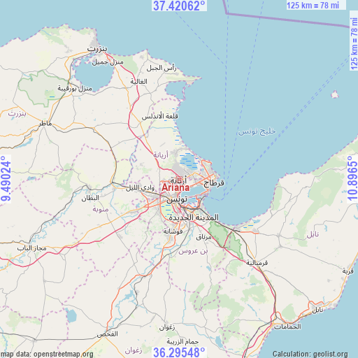
Ariana GPS coordinates[2]
36° 51' 36.432" North, 10° 11' 36.132" East
| Map corner | latitude | longitude |
|---|---|---|
| Upper-left | 37.42062°, | 9.49024° |
| Center: | 36.86012°, | 10.19337° |
| Lower-right: | 36.29548°, | 10.8965° |
| Map W x H: | 125.1×125.1 km | = 77.7×77.7mi |
| max Lat: | 37.27442° ⇑12.6% North |
| Ariana: | 36.86012° |
| min Lat: | ⇓87.4% South 32.31662° |
| min Long | Ariana | max Long |
| 7.87765° | 10.19337° | 11.21965° |
| W 51%⇐ | ⇒49% E |
Elevation
Elevation of Ariana is 11 m = 36 ft, and this is 138.4 m = 454 ft below average elevation for this country.
| Max E: |
999 m = 3278 ft | 82.5% |
| Avg. | 149.4 m = 490 ft | |
| Ariana | 11 m = 36 ft | |
Min E: |
-6 m = -20 ft | 17.5% |
See also: Ariana elevation on elevation.city.
Geographical zone
Ariana is located in North temperate zone (between Tropic of Cancer and the Arctic Circle). Distance of this Northern Tropic circle is 1492.5 km =927.4 mi to South.| Distance of | km | miles | from Ariana |
|---|---|---|---|
| North Pole | 5908.6 | 3671.4 | to North |
| Arctic Circle | 3302.7 | 2052.2 | to North |
| Tropic Cancer | 1492.5 | 927.4 | to South |
| Equator | 4098.5 | 2546.7 | to South |


Nearby cities:
15 places around Ariana: (largest is in red/bold)
• Al Marsá
11.8 km =7.3 mi,  80°
80°
• Ben Arous
12 km =7.5 mi,  167°
167°
• Carthage
12.3 km =7.6 mi,  89°
89°
• El Battan
31.7 km =19.7 mi,  258°
258°
• Galaat el Andeless
23.5 km =14.6 mi,  343°
343°
• Hammam-Lif
19.7 km =12.2 mi,  137°
137°
• La Goulette
11 km =6.8 mi,  115°
115°
• La Mohammedia
20.9 km =13 mi,  189°
189°
• La Sebala du Mornag
21.9 km =13.6 mi,  156°
156°
• Manouba
10.3 km =6.4 mi,  237°
237°
• Oued Lill
13.9 km =8.6 mi, 257°
• Radès
12.4 km =7.7 mi, 144°
• Sidi Bou Saïd
13.2 km =8.2 mi, 85°
• Tunis
5.2 km =3.2 mi,  208°
208°
• Zahānah
24.2 km =15 mi,  325°
325°
Sources, notices
• [Note1] Compared only with cities in Tunisia existing in our database
• [Src1] Map data: © OpenStreetMap contributors (CC-BY-SA)
• [Src2] Other city data from geonames.org with taken over terms of usage.
• [Src3] Geographical zone / Annual Mean Temperature by Robert A. Rohde @ Wikipedia
