Kélibia geodata
Kélibia (Nābul) is a populated place; located in Tunisia in Africa/Tunis (GMT+1) time zone. With population of 43,209 people, there are 33 cities with bigger population in this country. Compared to other cities in Tunisia, 86.7% of cities are located further ↓South; 97.9% of cities are located further ←West and 82.5% of cities have higher elevation than Kélibia. Note1


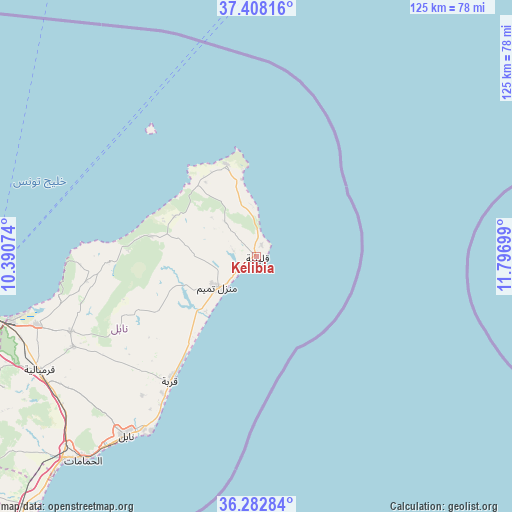
Kélibia GPS coordinates[2]
36° 50' 51.252" North, 11° 5' 37.896" East
| Map corner | latitude | longitude |
|---|---|---|
| Upper-left | 37.40816°, | 10.39074° |
| Center: | 36.84757°, | 11.09386° |
| Lower-right: | 36.28284°, | 11.79699° |
| Map W x H: | 125.1×125.1 km | = 77.7×77.7mi |
| max Lat: | 37.27442° ⇑13.3% North |
| Kélibia: | 36.84757° |
| min Lat: | ⇓86.7% South 32.31662° |
| min Long | Kélibia | max Long |
| 7.87765° | 11.09386° | 11.21965° |
| W 97.9%⇐ | ⇒2.1% E |
Elevation
Elevation of Kélibia is 11 m = 36 ft, and this is 138.4 m = 454 ft below average elevation for this country.
| Max E: |
999 m = 3278 ft | 82.5% |
| Avg. | 149.4 m = 490 ft | |
| Kélibia | 11 m = 36 ft | |
Min E: |
-6 m = -20 ft | 17.5% |
See also: Kélibia elevation on elevation.city.
Geographical zone
Kélibia is located in North temperate zone (between Tropic of Cancer and the Arctic Circle). Distance of this Northern Tropic circle is 1491.1 km =926.5 mi to South.| Distance of | km | miles | from Kélibia |
|---|---|---|---|
| North Pole | 5910 | 3672.3 | to North |
| Arctic Circle | 3304.1 | 2053.1 | to North |
| Tropic Cancer | 1491.1 | 926.5 | to South |
| Equator | 4097.1 | 2545.8 | to South |


Nearby cities:
15 places around Kélibia: (largest is in red/bold)
• Beni Khalled
50 km =31.1 mi,  243°
243°
• Beni Khiar
50.4 km =31.3 mi,  213°
213°
• Bou Arkoub
59.4 km =36.9 mi,  234°
234°
• Dar Chabanne
52.1 km =32.4 mi,  215°
215°
• Douane
53.7 km =33.4 mi, 214°
• El Haouaria
23.6 km =14.7 mi,  342°
342°
• El Maamoura
49.7 km =30.9 mi, 211°
• El Mida
25.2 km =15.7 mi, 237°
• Korba
36.5 km =22.7 mi, 215°
• Korbous
46.9 km =29.1 mi,  265°
265°
• Mennzel Bou Zelfa
48.9 km =30.4 mi,  248°
248°
• Menzel Heurr
18 km =11.2 mi, 222°
• Nabeul
53.9 km =33.5 mi, 216°
• Takelsa
41.6 km =25.8 mi,  260°
260°
• Zaouiat Djedidi
51.5 km =32 mi, 243°
Sources, notices
• [Note1] Compared only with cities in Tunisia existing in our database
• [Src1] Map data: © OpenStreetMap contributors (CC-BY-SA)
• [Src2] Other city data from geonames.org with taken over terms of usage.
• [Src3] Geographical zone / Annual Mean Temperature by Robert A. Rohde @ Wikipedia
