El Haouaria geodata
El Haouaria (Nābul) is a populated place; located in Tunisia in Africa/Tunis (GMT+1) time zone. With population of 9,273 people, there are 87 cities with bigger population in this country. Compared to other cities in Tunisia, 92.3% of cities are located further ↓South; 94.4% of cities are located further ←West and 62.2% of cities have higher elevation than El Haouaria. Note1


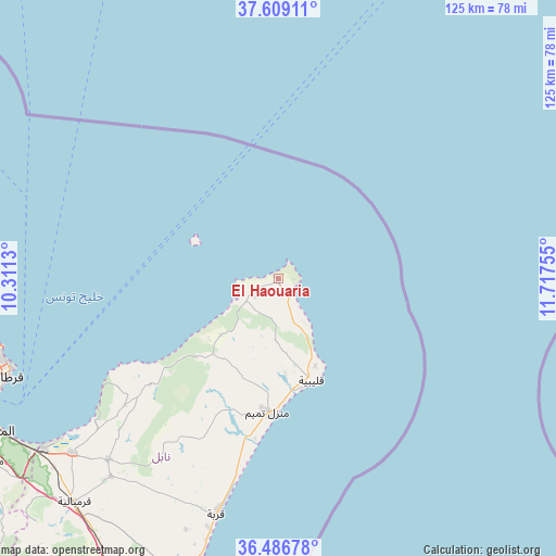
El Haouaria GPS coordinates[2]
37° 3' 0.072" North, 11° 0' 51.912" East
| Map corner | latitude | longitude |
|---|---|---|
| Upper-left | 37.60911°, | 10.3113° |
| Center: | 37.05002°, | 11.01442° |
| Lower-right: | 36.48678°, | 11.71755° |
| Map W x H: | 124.8×124.8 km | = 77.5×77.5mi |
| max Lat: | 37.27442° ⇑7.7% North |
| El Haouaria: | 37.05002° |
| min Lat: | ⇓92.3% South 32.31662° |
| min Long | El Haouaria | max Long |
| 7.87765° | 11.01442° | 11.21965° |
| W 94.4%⇐ | ⇒5.6% E |
Elevation
Elevation of El Haouaria is 28 m = 92 ft, and this is 121.4 m = 398 ft below average elevation for this country.
| Max E: |
999 m = 3278 ft | 62.2% |
| Avg. | 149.4 m = 490 ft | |
| El Haouaria | 28 m = 92 ft | |
Min E: |
-6 m = -20 ft | 37.8% |
See also: Tunisia elevation on elevation.city.
Geographical zone
El Haouaria is located in North temperate zone (between Tropic of Cancer and the Arctic Circle). Distance of this Northern Tropic circle is 1513.7 km =940.6 mi to South.| Distance of | km | miles | from El Haouaria |
|---|---|---|---|
| North Pole | 5887.5 | 3658.3 | to North |
| Arctic Circle | 3281.6 | 2039.1 | to North |
| Tropic Cancer | 1513.7 | 940.6 | to South |
| Equator | 4119.6 | 2559.8 | to South |


Nearby cities:
15 places around El Haouaria: (largest is in red/bold)
• Al Marsá
64.2 km =39.9 mi,  252°
252°
• Beni Khalled
58.3 km =36.2 mi,  220°
220°
• Beni Khiar
67.8 km =42.1 mi,  197°
197°
• Carthage
64.2 km =39.9 mi, 250°
• El Maamoura
67.6 km =42 mi, 195°
• El Mida
38.8 km =24.1 mi, 201°
• Korba
54.2 km =33.7 mi,  194°
194°
• Korbous
47.4 km =29.5 mi,  236°
236°
• Kélibia
23.6 km =14.7 mi,  162°
162°
• La Goulette
68.1 km =42.3 mi, 247°
• Mennzel Bou Zelfa
55.9 km =34.7 mi, 223°
• Menzel Heurr
36.1 km =22.4 mi, 188°
• Sidi Bou Saïd
63.1 km =39.2 mi, 251°
• Takelsa
45 km =28 mi,  228°
228°
• Zaouiat Djedidi
59.8 km =37.2 mi, 220°
Sources, notices
• [Note1] Compared only with cities in Tunisia existing in our database
• [Src1] Map data: © OpenStreetMap contributors (CC-BY-SA)
• [Src2] Other city data from geonames.org with taken over terms of usage.
• [Src3] Geographical zone / Annual Mean Temperature by Robert A. Rohde @ Wikipedia
