Chebba geodata
Chebba (Al Mahdīyah) is a populated place; located in Tunisia in Africa/Tunis (GMT+1) time zone. With population of 21,559 people, there are 52 cities with bigger population in this country. Compared to other cities in Tunisia, 74.1% of cities are located further ↑North; 99.3% of cities are located further ←West and 97.9% of cities have higher elevation than Chebba. Note1


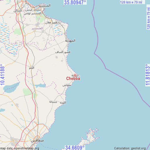
Chebba GPS coordinates[2]
35° 14' 13.992" North, 11° 6' 54" East
| Map corner | latitude | longitude |
|---|---|---|
| Upper-left | 35.80947°, | 10.41188° |
| Center: | 35.23722°, | 11.115° |
| Lower-right: | 34.6609°, | 11.81813° |
| Map W x H: | 127.7×127.7 km | = 79.3×79.3mi |
| max Lat: | 37.27442° ⇑74.1% North |
| Chebba: | 35.23722° |
| min Lat: | ⇓25.9% South 32.31662° |
| min Long | Chebba | max Long |
| 7.87765° | 11.115° | 11.21965° |
| W 99.3%⇐ | ⇒0.7% E |
Elevation
Elevation of Chebba is 3 m = 10 ft, and this is 146.4 m = 480 ft below average elevation for this country.
| Max E: |
999 m = 3278 ft | 97.9% |
| Avg. | 149.4 m = 490 ft | |
| Chebba | 3 m = 10 ft | |
Min E: |
-6 m = -20 ft | 2.1% |
See also: Tunisia elevation on elevation.city.
Geographical zone
Chebba is located in North temperate zone (between Tropic of Cancer and the Arctic Circle). Distance of this Northern Tropic circle is 1312.1 km =815.3 mi to South.| Distance of | km | miles | from Chebba |
|---|---|---|---|
| North Pole | 6089.1 | 3783.6 | to North |
| Arctic Circle | 3483.2 | 2164.4 | to North |
| Tropic Cancer | 1312.1 | 815.3 | to South |
| Equator | 3918 | 2434.5 | to South |


Nearby cities:
15 places around Chebba: (largest is in red/bold)
• Bekalta
43.7 km =27.2 mi,  345°
345°
• Beni Hassane
46 km =28.6 mi,  322°
322°
• Djebeniana
29.3 km =18.2 mi,  219°
219°
• El Jem
36.8 km =22.9 mi,  280°
280°
• Ksar Hellal
50 km =31.1 mi,  335°
335°
• Ksour Essaf
22.9 km =14.2 mi,  331°
331°
• Lemta
52.2 km =32.4 mi, 336°
• Mahdia
30.1 km =18.7 mi, 350°
• Melloulèche
10.7 km =6.6 mi, 222°
• Salakta
18.6 km =11.6 mi, 339°
• Seïada
52.1 km =32.4 mi, 337°
• Sidi Alouane
22.1 km =13.7 mi,  313°
313°
• Sidi Ben Nour
37.5 km =23.3 mi, 331°
• Touza
51.4 km =31.9 mi, 329°
• Zouila
29.7 km =18.5 mi, 350°
Sources, notices
• [Note1] Compared only with cities in Tunisia existing in our database
• [Src1] Map data: © OpenStreetMap contributors (CC-BY-SA)
• [Src2] Other city data from geonames.org with taken over terms of usage.
• [Src3] Geographical zone / Annual Mean Temperature by Robert A. Rohde @ Wikipedia
