Mahdia geodata
Mahdia (Al Mahdīyah) is a seat of a first-order administrative division; located in Tunisia in Africa/Tunis (GMT+1) time zone. With population of 45,977 people, there are 30 cities with bigger population in this country. Compared to other cities in Tunisia, 68.5% of cities are located further ↑North; 97.2% of cities are located further ←West and 91.6% of cities have higher elevation than Mahdia. Note1


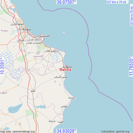
Mahdia GPS coordinates[2]
35° 30' 16.992" North, 11° 3' 43.992" East
| Map corner | latitude | longitude |
|---|---|---|
| Upper-left | 36.07507°, | 10.3591° |
| Center: | 35.50472°, | 11.06222° |
| Lower-right: | 34.93029°, | 11.76535° |
| Map W x H: | 127.3×127.3 km | = 79.1×79.1mi |
| max Lat: | 37.27442° ⇑68.5% North |
| Mahdia: | 35.50472° |
| min Lat: | ⇓31.5% South 32.31662° |
| min Long | Mahdia | max Long |
| 7.87765° | 11.06222° | 11.21965° |
| W 97.2%⇐ | ⇒2.8% E |
Elevation
Elevation of Mahdia is 7 m = 23 ft, and this is 142.4 m = 467 ft below average elevation for this country.
| Max E: |
999 m = 3278 ft | 91.6% |
| Avg. | 149.4 m = 490 ft | |
| Mahdia | 7 m = 23 ft | |
Min E: |
-6 m = -20 ft | 8.4% |
See also: Mahdia elevation on elevation.city.
Geographical zone
Mahdia is located in North temperate zone (between Tropic of Cancer and the Arctic Circle). Distance of this Northern Tropic circle is 1341.8 km =833.8 mi to South.| Distance of | km | miles | from Mahdia |
|---|---|---|---|
| North Pole | 6059.3 | 3765.1 | to North |
| Arctic Circle | 3453.4 | 2145.8 | to North |
| Tropic Cancer | 1341.8 | 833.8 | to South |
| Equator | 3947.8 | 2453 | to South |


Nearby cities:
15 places around Mahdia: (largest is in red/bold)
• Banbalah
32.1 km =19.9 mi,  312°
312°
• Bekalta
13.9 km =8.6 mi,  333°
333°
• Beni Hassane
24 km =14.9 mi,  286°
286°
• Chebba
30.1 km =18.7 mi,  170°
170°
• Djemmal
30.5 km =19 mi,  295°
295°
• Ksar Hellal
22.2 km =13.8 mi,  315°
315°
• Ksibet el Mediouni
28.3 km =17.6 mi, 315°
• Ksour Essaf
11.4 km =7.1 mi,  212°
212°
• Lemta
24.2 km =15 mi, 318°
• Salakta
12.4 km =7.7 mi,  187°
187°
• Seïada
23.8 km =14.8 mi, 319°
• Sidi Alouane
18.2 km =11.3 mi,  217°
217°
• Sidi Ben Nour
13.6 km =8.5 mi,  283°
283°
• Touza
25.7 km =16 mi, 304°
• Zouila
0.5 km =0.3 mi,  197°
197°
Sources, notices
• [Note1] Compared only with cities in Tunisia existing in our database
• [Src1] Map data: © OpenStreetMap contributors (CC-BY-SA)
• [Src2] Other city data from geonames.org with taken over terms of usage.
• [Src3] Geographical zone / Annual Mean Temperature by Robert A. Rohde @ Wikipedia
