Sultangazi geodata
Sultangazi (Istanbul) is a populated place; located in Turkey in Europe/Istanbul (GMT+3) time zone. With population of 436,935 people, there are 22 cities with bigger population in this country. Compared to other cities in Turkey, 92.5% of cities are located further ↓South; 85% of cities are located further →East and 77.5% of cities have higher elevation than Sultangazi. Note1


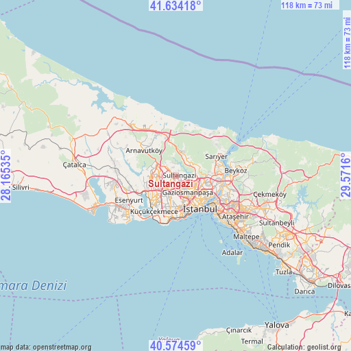
Sultangazi GPS coordinates[2]
41° 6' 23.472" North, 28° 52' 6.492" East
| Map corner | latitude | longitude |
|---|---|---|
| Upper-left | 41.63418°, | 28.16535° |
| Center: | 41.10652°, | 28.86847° |
| Lower-right: | 40.57459°, | 29.5716° |
| Map W x H: | 117.8×117.8 km | = 73.2×73.2mi |
| max Lat: | 42.02683° ⇑7.5% North |
| Sultangazi: | 41.10652° |
| min Lat: | ⇓92.5% South 35.9025° |
| min Long | Sultangazi | max Long |
| 25.90902° | 28.86847° | 44.60099° |
| W 15%⇐ | ⇒85% E |
Elevation
Elevation of Sultangazi is 144 m = 472 ft, and this is 573.4 m = 1881 ft below average elevation for this country.
| Max E: |
2682 m = 8799 ft | 77.5% |
| Avg. | 717.4 m = 2354 ft | |
| Sultangazi | 144 m = 472 ft | |
Min E: |
0 m = 0 ft | 22.5% |
See also: Sultangazi elevation on elevation.city.
Geographical zone
Sultangazi is located in North temperate zone (between Tropic of Cancer and the Arctic Circle). Distance of this Northern Tropic circle is 1964.7 km =1220.8 mi to South.| Distance of | km | miles | from Sultangazi |
|---|---|---|---|
| North Pole | 5436.4 | 3378 | to North |
| Arctic Circle | 2830.6 | 1758.9 | to North |
| Tropic Cancer | 1964.7 | 1220.8 | to South |
| Equator | 4570.6 | 2840 | to South |


Nearby cities:
15 places around Sultangazi: (largest is in red/bold)
• Arnavutköy
13.7 km =8.5 mi,  308°
308°
• Arıköy
17.9 km =11.1 mi,  39°
39°
• Bahçelievler
11.6 km =7.2 mi,  183°
183°
• Bağcılar
7.6 km =4.7 mi,  187°
187°
• Başakşehir
5.8 km =3.6 mi,  254°
254°
• Eminönü
13.3 km =8.3 mi,  138°
138°
• Esenler
7 km =4.3 mi,  174°
174°
• Istanbul
12.4 km =7.7 mi,  146°
146°
• Kemerburgaz
7.1 km =4.4 mi,  34°
34°
• Mahmutbey
6.9 km =4.3 mi,  211°
211°
• Merter Keresteciler
10.5 km =6.5 mi, 171°
• Zeytinburnu
12.8 km =8 mi, 166°
• güngören merter
11.2 km =7 mi, 171°
• Üsküdar
15.3 km =9.5 mi,  127°
127°
• Şişli
11.2 km =7 mi,  117°
117°
Sources, notices
• [Note1] Compared only with cities in Turkey existing in our database
• [Src1] Map data: © OpenStreetMap contributors (CC-BY-SA)
• [Src2] Other city data from geonames.org with taken over terms of usage.
• [Src3] Geographical zone / Annual Mean Temperature by Robert A. Rohde @ Wikipedia
