Ortaköy geodata
Ortaköy (Sakarya) is a seat of a third-order administrative division; located in Turkey in Europe/Istanbul (GMT+3) time zone. In our database, there are 1323 cities with bigger population. Compared to other cities in Turkey, 88.2% of cities are located further ↓South; 72% of cities are located further →East and 70.7% of cities have higher elevation than Ortaköy. Note1


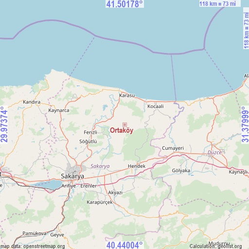
Ortaköy GPS coordinates[2]
40° 58' 22.98" North, 30° 40' 36.696" East
| Map corner | latitude | longitude |
|---|---|---|
| Upper-left | 41.50178°, | 29.97374° |
| Center: | 40.97305°, | 30.67686° |
| Lower-right: | 40.44004°, | 31.37999° |
| Map W x H: | 118.1×118.1 km | = 73.4×73.4mi |
| max Lat: | 42.02683° ⇑11.8% North |
| Ortaköy: | 40.97305° |
| min Lat: | ⇓88.2% South 35.9025° |
| min Long | Ortaköy | max Long |
| 25.90902° | 30.67686° | 44.60099° |
| W 28%⇐ | ⇒72% E |
Elevation
Elevation of Ortaköy is 272 m = 892 ft, and this is 445.4 m = 1461 ft below average elevation for this country.
| Max E: |
2682 m = 8799 ft | 70.7% |
| Avg. | 717.4 m = 2354 ft | |
| Ortaköy | 272 m = 892 ft | |
Min E: |
0 m = 0 ft | 29.3% |
See also: Turkey elevation on elevation.city.
Geographical zone
Ortaköy is located in North temperate zone (between Tropic of Cancer and the Arctic Circle). Distance of this Northern Tropic circle is 1949.9 km =1211.6 mi to South.| Distance of | km | miles | from Ortaköy |
|---|---|---|---|
| North Pole | 5451.3 | 3387.3 | to North |
| Arctic Circle | 2845.4 | 1768 | to North |
| Tropic Cancer | 1949.9 | 1211.6 | to South |
| Equator | 4555.8 | 2830.8 | to South |


Nearby cities:
15 places around Ortaköy: (largest is in red/bold)
• Adapazarı
31.4 km =19.5 mi,  227°
227°
• Akyazı
32.4 km =20.1 mi,  188°
188°
• Cumayeri
25.5 km =15.8 mi,  115°
115°
• Erenler
34 km =21.1 mi,  224°
224°
• Ferizli
16.4 km =10.2 mi,  257°
257°
• Gümüşova
26.3 km =16.3 mi, 122°
• Hendek
20.2 km =12.6 mi,  162°
162°
• Karadere
30.1 km =18.7 mi,  152°
152°
• Karasu
14.7 km =9.1 mi,  6°
6°
• Karasu Mahallesi
14.2 km =8.8 mi,  39°
39°
• Kaynarca
31.7 km =19.7 mi,  281°
281°
• Kocaali
17.3 km =10.7 mi,  58°
58°
• Serdivan
33.4 km =20.8 mi, 228°
• Söğütlü
18.6 km =11.6 mi,  246°
246°
• Çilimli
32.5 km =20.2 mi,  105°
105°
Sources, notices
• [Note1] Compared only with cities in Turkey existing in our database
• [Src1] Map data: © OpenStreetMap contributors (CC-BY-SA)
• [Src2] Other city data from geonames.org with taken over terms of usage.
• [Src3] Geographical zone / Annual Mean Temperature by Robert A. Rohde @ Wikipedia
