Hendek geodata
Hendek (Sakarya) is a seat of a second-order administrative division; located in Turkey in Europe/Istanbul (GMT+3) time zone. With population of 35,257 people, there are 224 cities with bigger population in this country. Compared to other cities in Turkey, 83.6% of cities are located further ↓South; 71.6% of cities are located further →East and 74.3% of cities have higher elevation than Hendek. Note1


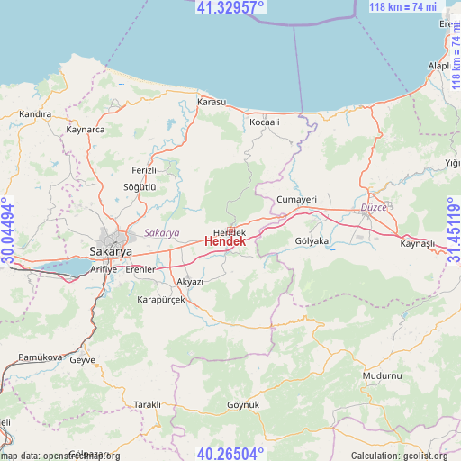
Hendek GPS coordinates[2]
40° 47' 57.984" North, 30° 44' 53.016" East
| Map corner | latitude | longitude |
|---|---|---|
| Upper-left | 41.32957°, | 30.04494° |
| Center: | 40.79944°, | 30.74806° |
| Lower-right: | 40.26504°, | 31.45119° |
| Map W x H: | 118.4×118.4 km | = 73.6×73.6mi |
| max Lat: | 42.02683° ⇑16.4% North |
| Hendek: | 40.79944° |
| min Lat: | ⇓83.6% South 35.9025° |
| min Long | Hendek | max Long |
| 25.90902° | 30.74806° | 44.60099° |
| W 28.4%⇐ | ⇒71.6% E |
Elevation
Elevation of Hendek is 185 m = 607 ft, and this is 532.4 m = 1747 ft below average elevation for this country.
| Max E: |
2682 m = 8799 ft | 74.3% |
| Avg. | 717.4 m = 2354 ft | |
| Hendek | 185 m = 607 ft | |
Min E: |
0 m = 0 ft | 25.7% |
See also: Turkey elevation on elevation.city.
Geographical zone
Hendek is located in North temperate zone (between Tropic of Cancer and the Arctic Circle). Distance of this Northern Tropic circle is 1930.6 km =1199.6 mi to South.| Distance of | km | miles | from Hendek |
|---|---|---|---|
| North Pole | 5470.6 | 3399.3 | to North |
| Arctic Circle | 2864.7 | 1780 | to North |
| Tropic Cancer | 1930.6 | 1199.6 | to South |
| Equator | 4536.5 | 2818.8 | to South |


Nearby cities:
15 places around Hendek: (largest is in red/bold)
• Adapazarı
29.1 km =18.1 mi,  265°
265°
• Akyazı
16.6 km =10.3 mi,  219°
219°
• Cumayeri
19 km =11.8 mi,  64°
64°
• Dokurcun
27.1 km =16.8 mi,  158°
158°
• Erenler
30.3 km =18.8 mi,  260°
260°
• Ferizli
27.1 km =16.8 mi,  305°
305°
• Gölyaka
21 km =13 mi,  96°
96°
• Gümüşova
17.1 km =10.6 mi,  71°
71°
• Karadere
10.8 km =6.7 mi,  134°
134°
• Karapürçek
24.8 km =15.4 mi,  225°
225°
• Karasu Mahallesi
30.4 km =18.9 mi,  5°
5°
• Kocaali
29.6 km =18.4 mi,  17°
17°
• Ortaköy
20.2 km =12.6 mi,  342°
342°
• Söğütlü
25.9 km =16.1 mi,  297°
297°
• Çilimli
27.4 km =17 mi, 67°
Sources, notices
• [Note1] Compared only with cities in Turkey existing in our database
• [Src1] Map data: © OpenStreetMap contributors (CC-BY-SA)
• [Src2] Other city data from geonames.org with taken over terms of usage.
• [Src3] Geographical zone / Annual Mean Temperature by Robert A. Rohde @ Wikipedia
