Cumayeri geodata
Cumayeri (Düzce) is a seat of a second-order administrative division; located in Turkey in Europe/Istanbul (GMT+3) time zone. In our database, there are 1323 cities with bigger population. Compared to other cities in Turkey, 85.4% of cities are located further ↓South; 70.9% of cities are located further →East and 78.6% of cities have higher elevation than Cumayeri. Note1


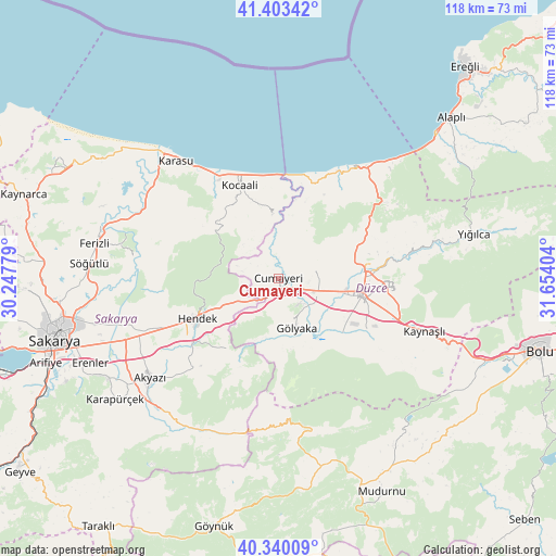
Cumayeri GPS coordinates[2]
40° 52' 26.004" North, 30° 57' 3.276" East
| Map corner | latitude | longitude |
|---|---|---|
| Upper-left | 41.40342°, | 30.24779° |
| Center: | 40.87389°, | 30.95091° |
| Lower-right: | 40.34009°, | 31.65404° |
| Map W x H: | 118.2×118.2 km | = 73.4×73.4mi |
| max Lat: | 42.02683° ⇑14.6% North |
| Cumayeri: | 40.87389° |
| min Lat: | ⇓85.4% South 35.9025° |
| min Long | Cumayeri | max Long |
| 25.90902° | 30.95091° | 44.60099° |
| W 29.1%⇐ | ⇒70.9% E |
Elevation
Elevation of Cumayeri is 130 m = 427 ft, and this is 587.4 m = 1927 ft below average elevation for this country.
| Max E: |
2682 m = 8799 ft | 78.6% |
| Avg. | 717.4 m = 2354 ft | |
| Cumayeri | 130 m = 427 ft | |
Min E: |
0 m = 0 ft | 21.4% |
See also: Turkey elevation on elevation.city.
Geographical zone
Cumayeri is located in North temperate zone (between Tropic of Cancer and the Arctic Circle). Distance of this Northern Tropic circle is 1938.8 km =1204.7 mi to South.| Distance of | km | miles | from Cumayeri |
|---|---|---|---|
| North Pole | 5462.3 | 3394.1 | to North |
| Arctic Circle | 2856.4 | 1774.9 | to North |
| Tropic Cancer | 1938.8 | 1204.7 | to South |
| Equator | 4544.8 | 2824 | to South |


Nearby cities:
15 places around Cumayeri: (largest is in red/bold)
• Akyazı
34.7 km =21.6 mi,  232°
232°
• Akçakoca
27.4 km =17 mi,  30°
30°
• Dokurcun
34.2 km =21.3 mi,  191°
191°
• Düzce
18.3 km =11.4 mi,  102°
102°
• Gölyaka
11.4 km =7.1 mi,  160°
160°
• Gümüşova
3.1 km =1.9 mi,  195°
195°
• Hendek
19 km =11.8 mi,  244°
244°
• Karadere
18.4 km =11.4 mi,  210°
210°
• Karasu
33.4 km =20.8 mi,  320°
320°
• Karasu Mahallesi
25.9 km =16.1 mi,  327°
327°
• Kaynaşlı
33.3 km =20.7 mi,  110°
110°
• Kocaali
21.6 km =13.4 mi,  337°
337°
• Konuralp
16.7 km =10.4 mi,  77°
77°
• Ortaköy
25.5 km =15.8 mi,  295°
295°
• Çilimli
8.5 km =5.3 mi, 75°
Sources, notices
• [Note1] Compared only with cities in Turkey existing in our database
• [Src1] Map data: © OpenStreetMap contributors (CC-BY-SA)
• [Src2] Other city data from geonames.org with taken over terms of usage.
• [Src3] Geographical zone / Annual Mean Temperature by Robert A. Rohde @ Wikipedia
