Yediyol geodata
Yediyol (Şanlıurfa) is a populated place; located in Turkey in Europe/Istanbul (GMT+3) time zone. With population of 653 people, there are 1225 cities with bigger population in this country. Compared to other cities in Turkey, 88.1% of cities are located further ↑North; 66.9% of cities are located further ←West and 66% of cities have higher elevation than Yediyol. Note1


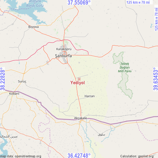
Yediyol GPS coordinates[2]
36° 59' 28.176" North, 38° 55' 53.04" East
| Map corner | latitude | longitude |
|---|---|---|
| Upper-left | 37.55069°, | 38.22828° |
| Center: | 36.99116°, | 38.9314° |
| Lower-right: | 36.42748°, | 39.63453° |
| Map W x H: | 124.9×124.9 km | = 77.6×77.6mi |
| max Lat: | 42.02683° ⇑88.1% North |
| Yediyol: | 36.99116° |
| min Lat: | ⇓11.9% South 35.9025° |
| min Long | Yediyol | max Long |
| 25.90902° | 38.9314° | 44.60099° |
| W 66.9%⇐ | ⇒33.1% E |
Elevation
Elevation of Yediyol is 390 m = 1280 ft, and this is 327.4 m = 1074 ft below average elevation for this country.
| Max E: |
2682 m = 8799 ft | 66% |
| Avg. | 717.4 m = 2354 ft | |
| Yediyol | 390 m = 1280 ft | |
Min E: |
0 m = 0 ft | 34% |
See also: Turkey elevation on elevation.city.
Geographical zone
Yediyol is located in North temperate zone (between Tropic of Cancer and the Arctic Circle). Distance of this Northern Tropic circle is 1507.1 km =936.5 mi to South.| Distance of | km | miles | from Yediyol |
|---|---|---|---|
| North Pole | 5894 | 3662.4 | to North |
| Arctic Circle | 3288.1 | 2043.1 | to North |
| Tropic Cancer | 1507.1 | 936.5 | to South |
| Equator | 4113 | 2555.7 | to South |


Nearby cities:
15 places around Yediyol: (largest is in red/bold)
• Balkat
14.7 km =9.1 mi,  158°
158°
• Eskiharran
13.2 km =8.2 mi,  120°
120°
• Hacıekber
19.5 km =12.1 mi,  176°
176°
• Haktanır
16.3 km =10.1 mi,  201°
201°
• Harran
17.1 km =10.6 mi,  148°
148°
• Karatepe
11.3 km =7 mi, 203°
• Keçikıran
5.5 km =3.4 mi, 120°
• Minare
9.3 km =5.8 mi,  135°
135°
• Ozanlar
5.9 km =3.7 mi,  209°
209°
• Parapara
5 km =3.1 mi,  165°
165°
• Seksenören
12.9 km =8 mi,  99°
99°
• Tahılalan
15.7 km =9.8 mi, 166°
• Yardımcı
7.4 km =4.6 mi,  63°
63°
• Yukarı Beğdeş
16.3 km =10.1 mi,  188°
188°
• Yukarı Çaykuyu
16 km =9.9 mi,  271°
271°
Sources, notices
• [Note1] Compared only with cities in Turkey existing in our database
• [Src1] Map data: © OpenStreetMap contributors (CC-BY-SA)
• [Src2] Other city data from geonames.org with taken over terms of usage.
• [Src3] Geographical zone / Annual Mean Temperature by Robert A. Rohde @ Wikipedia
