Seksenören geodata
Seksenören (Şanlıurfa) is a populated place; located in Turkey in Europe/Istanbul (GMT+3) time zone. With population of 1,054 people, there are 1079 cities with bigger population in this country. Compared to other cities in Turkey, 88.7% of cities are located further ↑North; 68.4% of cities are located further ←West and 66.1% of cities have higher elevation than Seksenören. Note1


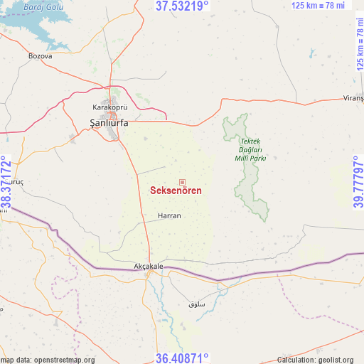
Seksenören GPS coordinates[2]
36° 58' 21.072" North, 39° 4' 29.424" East
| Map corner | latitude | longitude |
|---|---|---|
| Upper-left | 37.53219°, | 38.37172° |
| Center: | 36.97252°, | 39.07484° |
| Lower-right: | 36.40871°, | 39.77797° |
| Map W x H: | 124.9×124.9 km | = 77.6×77.6mi |
| max Lat: | 42.02683° ⇑88.7% North |
| Seksenören: | 36.97252° |
| min Lat: | ⇓11.3% South 35.9025° |
| min Long | Seksenören | max Long |
| 25.90902° | 39.07484° | 44.60099° |
| W 68.4%⇐ | ⇒31.6% E |
Elevation
Elevation of Seksenören is 389 m = 1276 ft, and this is 328.4 m = 1077 ft below average elevation for this country.
| Max E: |
2682 m = 8799 ft | 66.1% |
| Avg. | 717.4 m = 2354 ft | |
| Seksenören | 389 m = 1276 ft | |
Min E: |
0 m = 0 ft | 33.9% |
See also: Turkey elevation on elevation.city.
Geographical zone
Seksenören is located in North temperate zone (between Tropic of Cancer and the Arctic Circle). Distance of this Northern Tropic circle is 1505 km =935.2 mi to South.| Distance of | km | miles | from Seksenören |
|---|---|---|---|
| North Pole | 5896.1 | 3663.7 | to North |
| Arctic Circle | 3290.2 | 2044.4 | to North |
| Tropic Cancer | 1505 | 935.2 | to South |
| Equator | 4111 | 2554.5 | to South |


Nearby cities:
15 places around Seksenören: (largest is in red/bold)
• Balkat
13.7 km =8.5 mi,  212°
212°
• Eskiharran
4.8 km =3 mi,  195°
195°
• Harran
13.1 km =8.1 mi, 197°
• Keçikıran
8 km =5 mi,  264°
264°
• Küplüce
18.4 km =11.4 mi,  194°
194°
• Minare
7.8 km =4.8 mi,  233°
233°
• Ozanlar
15.9 km =9.9 mi, 258°
• Parapara
11.8 km =7.3 mi, 256°
• Selalmaz
18.6 km =11.6 mi,  163°
163°
• Sugeldi
17.9 km =11.1 mi, 189°
• Tahılalan
16 km =9.9 mi, 214°
• Uluağaç
15.4 km =9.6 mi, 158°
• Yardımcı
8.2 km =5.1 mi,  311°
311°
• Yediyol
12.9 km =8 mi,  279°
279°
• Örenlı
18 km =11.2 mi,  88°
88°
Sources, notices
• [Note1] Compared only with cities in Turkey existing in our database
• [Src1] Map data: © OpenStreetMap contributors (CC-BY-SA)
• [Src2] Other city data from geonames.org with taken over terms of usage.
• [Src3] Geographical zone / Annual Mean Temperature by Robert A. Rohde @ Wikipedia
