Koçtepe geodata
Koçtepe (Şırnak) is a populated place; located in Turkey in Europe/Istanbul (GMT+3) time zone. With population of 603 people, there are 1249 cities with bigger population in this country. Compared to other cities in Turkey, 73.8% of cities are located further ↑North; 89.2% of cities are located further ←West and 62.5% of cities have higher elevation than Koçtepe. Note1


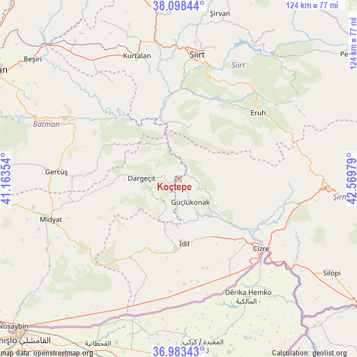
Koçtepe GPS coordinates[2]
37° 32' 34.872" North, 41° 51' 59.976" East
| Map corner | latitude | longitude |
|---|---|---|
| Upper-left | 38.09844°, | 41.16354° |
| Center: | 37.54302°, | 41.86666° |
| Lower-right: | 36.98343°, | 42.56979° |
| Map W x H: | 124×124 km | = 77.1×77.1mi |
| max Lat: | 42.02683° ⇑73.8% North |
| Koçtepe: | 37.54302° |
| min Lat: | ⇓26.2% South 35.9025° |
| min Long | Koçtepe | max Long |
| 25.90902° | 41.86666° | 44.60099° |
| W 89.2%⇐ | ⇒10.8% E |
Elevation
Elevation of Koçtepe is 463 m = 1519 ft, and this is 254.4 m = 835 ft below average elevation for this country.
| Max E: |
2682 m = 8799 ft | 62.5% |
| Avg. | 717.4 m = 2354 ft | |
| Koçtepe | 463 m = 1519 ft | |
Min E: |
0 m = 0 ft | 37.5% |
See also: Turkey elevation on elevation.city.
Geographical zone
Koçtepe is located in North temperate zone (between Tropic of Cancer and the Arctic Circle). Distance of this Northern Tropic circle is 1568.5 km =974.6 mi to South.| Distance of | km | miles | from Koçtepe |
|---|---|---|---|
| North Pole | 5832.7 | 3624.3 | to North |
| Arctic Circle | 3226.8 | 2005 | to North |
| Tropic Cancer | 1568.5 | 974.6 | to South |
| Equator | 4174.4 | 2593.9 | to South |


Nearby cities:
15 places around Koçtepe: (largest is in red/bold)
• Akdizgin
14.6 km =9.1 mi,  144°
144°
• Baraniferho
8.9 km =5.5 mi,  157°
157°
• Boyuncuk
13.6 km =8.5 mi, 164°
• Dargeçit
13.2 km =8.2 mi,  271°
271°
• Erenkaya
20.1 km =12.5 mi,  59°
59°
• Fındık
9.2 km =5.7 mi,  111°
111°
• Karabayır
5 km =3.1 mi,  298°
298°
• Kayaboyun
22.2 km =13.8 mi, 110°
• Kılavuz
10.2 km =6.3 mi,  226°
226°
• Lodi
19.3 km =12 mi,  12°
12°
• Sulak
16.6 km =10.3 mi,  149°
149°
• Suçatı
10 km =6.2 mi, 300°
• Temelli
4.1 km =2.5 mi,  333°
333°
• Yarbaşı
16.9 km =10.5 mi,  180°
180°
• Yelkesen
16.3 km =10.1 mi,  38°
38°
Sources, notices
• [Note1] Compared only with cities in Turkey existing in our database
• [Src1] Map data: © OpenStreetMap contributors (CC-BY-SA)
• [Src2] Other city data from geonames.org with taken over terms of usage.
• [Src3] Geographical zone / Annual Mean Temperature by Robert A. Rohde @ Wikipedia
