Baraniferho geodata
Baraniferho (Şırnak) is a seat of a second-order administrative division; located in Turkey in Europe/Istanbul (GMT+3) time zone. With population of 4,549 people, there are 753 cities with bigger population in this country. Compared to other cities in Turkey, 75.6% of cities are located further ↑North; 89.5% of cities are located further ←West and 54.3% of cities have lower elevation than Baraniferho. Note1


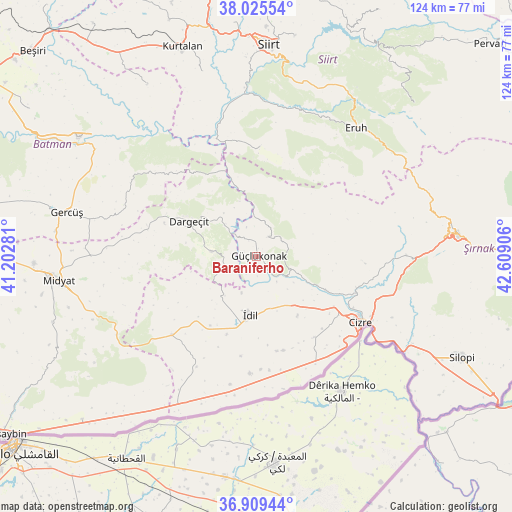
Baraniferho GPS coordinates[2]
37° 28' 10.452" North, 41° 54' 21.348" East
| Map corner | latitude | longitude |
|---|---|---|
| Upper-left | 38.02554°, | 41.20281° |
| Center: | 37.46957°, | 41.90593° |
| Lower-right: | 36.90944°, | 42.60906° |
| Map W x H: | 124.1×124.1 km | = 77.1×77.1mi |
| max Lat: | 42.02683° ⇑75.6% North |
| Baraniferho: | 37.46957° |
| min Lat: | ⇓24.4% South 35.9025° |
| min Long | Baraniferho | max Long |
| 25.90902° | 41.90593° | 44.60099° |
| W 89.5%⇐ | ⇒10.5% E |
Elevation
Elevation of Baraniferho is 779 m = 2556 ft, and this is 61.6 m = 202 ft above average elevation for this country.
| Max E: |
2682 m = 8799 ft | 45.7% |
| Baraniferho | 779 m 2556 ft | |
| Avg. | 717.4 m = 2354 ft | |
Min E: |
0 m = 0 ft | 54.3% |
See also: Turkey elevation on elevation.city.
Geographical zone
Baraniferho is located in North temperate zone (between Tropic of Cancer and the Arctic Circle). Distance of this Northern Tropic circle is 1560.3 km =969.5 mi to South.| Distance of | km | miles | from Baraniferho |
|---|---|---|---|
| North Pole | 5840.8 | 3629.3 | to North |
| Arctic Circle | 3234.9 | 2010.1 | to North |
| Tropic Cancer | 1560.3 | 969.5 | to South |
| Equator | 4166.2 | 2588.8 | to South |


Nearby cities:
15 places around Baraniferho: (largest is in red/bold)
• Akdizgin
6.2 km =3.9 mi,  127°
127°
• Boyuncuk
4.9 km =3 mi,  177°
177°
• Dargeçit
18.8 km =11.7 mi,  297°
297°
• Fındık
7.1 km =4.4 mi,  46°
46°
• Karabayır
13.1 km =8.1 mi,  323°
323°
• Kayaboyun
17.4 km =10.8 mi,  88°
88°
• Koçtepe
8.9 km =5.5 mi,  337°
337°
• Kılavuz
10.8 km =6.7 mi,  275°
275°
• Sulak
7.9 km =4.9 mi,  142°
142°
• Suçatı
17.9 km =11.1 mi, 317°
• Temelli
12.9 km =8 mi, 335°
• Tepeköy
20.2 km =12.6 mi,  200°
200°
• Tililan
15.5 km =9.6 mi, 133°
• Yarbaşı
9.4 km =5.8 mi, 202°
• İdil
15.1 km =9.4 mi,  185°
185°
Sources, notices
• [Note1] Compared only with cities in Turkey existing in our database
• [Src1] Map data: © OpenStreetMap contributors (CC-BY-SA)
• [Src2] Other city data from geonames.org with taken over terms of usage.
• [Src3] Geographical zone / Annual Mean Temperature by Robert A. Rohde @ Wikipedia
