Sultanhisar geodata
Sultanhisar (Aydın) is a seat of a second-order administrative division; located in Turkey in Europe/Istanbul (GMT+3) time zone. With population of 6,259 people, there are 645 cities with bigger population in this country. Compared to other cities in Turkey, 65.4% of cities are located further ↑North; 89% of cities are located further →East and 82.5% of cities have higher elevation than Sultanhisar. Note1


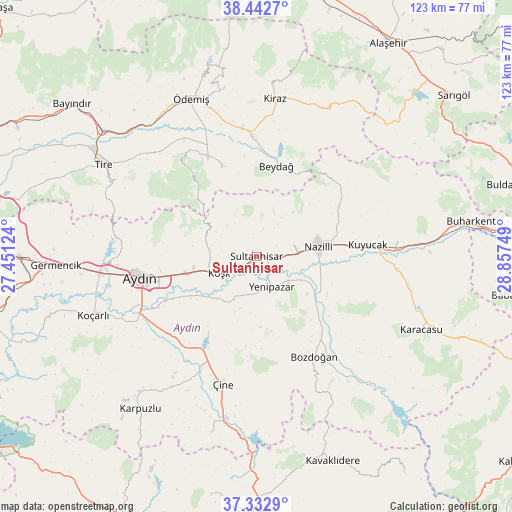
Sultanhisar GPS coordinates[2]
37° 53' 23.604" North, 28° 9' 15.696" East
| Map corner | latitude | longitude |
|---|---|---|
| Upper-left | 38.4427°, | 27.45124° |
| Center: | 37.88989°, | 28.15436° |
| Lower-right: | 37.3329°, | 28.85749° |
| Map W x H: | 123.4×123.4 km | = 76.7×76.7mi |
| max Lat: | 42.02683° ⇑65.4% North |
| Sultanhisar: | 37.88989° |
| min Lat: | ⇓34.6% South 35.9025° |
| min Long | Sultanhisar | max Long |
| 25.90902° | 28.15436° | 44.60099° |
| W 11%⇐ | ⇒89% E |
Elevation
Elevation of Sultanhisar is 89 m = 292 ft, and this is 628.4 m = 2062 ft below average elevation for this country.
| Max E: |
2682 m = 8799 ft | 82.5% |
| Avg. | 717.4 m = 2354 ft | |
| Sultanhisar | 89 m = 292 ft | |
Min E: |
0 m = 0 ft | 17.5% |
See also: Turkey elevation on elevation.city.
Geographical zone
Sultanhisar is located in North temperate zone (between Tropic of Cancer and the Arctic Circle). Distance of this Northern Tropic circle is 1607 km =998.5 mi to South.| Distance of | km | miles | from Sultanhisar |
|---|---|---|---|
| North Pole | 5794.1 | 3600.3 | to North |
| Arctic Circle | 3188.2 | 1981.1 | to North |
| Tropic Cancer | 1607 | 998.5 | to South |
| Equator | 4213 | 2617.8 | to South |


Nearby cities:
15 places around Sultanhisar: (largest is in red/bold)
• Atça
5.3 km =3.3 mi,  91°
91°
• Aydın
28.1 km =17.5 mi,  259°
259°
• Bademli
22.9 km =14.2 mi,  338°
338°
• Bozdoğan
28.1 km =17.5 mi,  150°
150°
• Dalama
13.5 km =8.4 mi,  214°
214°
• Konaklı
28.4 km =17.6 mi,  330°
330°
• Kuyucak
26.9 km =16.7 mi,  84°
84°
• Köşk
9.9 km =6.2 mi,  245°
245°
• Nazilli
15 km =9.3 mi, 78°
• Ovakent
26.8 km =16.7 mi, 334°
• Salavatlı
4.5 km =2.8 mi,  271°
271°
• Tepecik
25.6 km =15.9 mi, 253°
• Umurlu
17.4 km =10.8 mi, 255°
• Yenipazar
8.2 km =5.1 mi, 153°
• İsabeyli
9.8 km =6.1 mi, 82°
Sources, notices
• [Note1] Compared only with cities in Turkey existing in our database
• [Src1] Map data: © OpenStreetMap contributors (CC-BY-SA)
• [Src2] Other city data from geonames.org with taken over terms of usage.
• [Src3] Geographical zone / Annual Mean Temperature by Robert A. Rohde @ Wikipedia
