Bozdoğan geodata
Bozdoğan (Aydın) is a seat of a second-order administrative division; located in Turkey in Europe/Istanbul (GMT+3) time zone. With population of 8,378 people, there are 562 cities with bigger population in this country. Compared to other cities in Turkey, 71% of cities are located further ↑North; 88.1% of cities are located further →East and 70.5% of cities have higher elevation than Bozdoğan. Note1


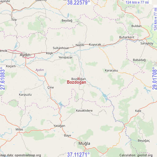
Bozdoğan GPS coordinates[2]
37° 40' 16.824" North, 28° 18' 50.22" East
| Map corner | latitude | longitude |
|---|---|---|
| Upper-left | 38.22579°, | 27.61083° |
| Center: | 37.67134°, | 28.31395° |
| Lower-right: | 37.11271°, | 29.01708° |
| Map W x H: | 123.8×123.8 km | = 76.9×76.9mi |
| max Lat: | 42.02683° ⇑71% North |
| Bozdoğan: | 37.67134° |
| min Lat: | ⇓29% South 35.9025° |
| min Long | Bozdoğan | max Long |
| 25.90902° | 28.31395° | 44.60099° |
| W 11.9%⇐ | ⇒88.1% E |
Elevation
Elevation of Bozdoğan is 275 m = 902 ft, and this is 442.4 m = 1451 ft below average elevation for this country.
| Max E: |
2682 m = 8799 ft | 70.5% |
| Avg. | 717.4 m = 2354 ft | |
| Bozdoğan | 275 m = 902 ft | |
Min E: |
0 m = 0 ft | 29.5% |
See also: Turkey elevation on elevation.city.
Geographical zone
Bozdoğan is located in North temperate zone (between Tropic of Cancer and the Arctic Circle). Distance of this Northern Tropic circle is 1582.7 km =983.4 mi to South.| Distance of | km | miles | from Bozdoğan |
|---|---|---|---|
| North Pole | 5818.4 | 3615.4 | to North |
| Arctic Circle | 3212.5 | 1996.2 | to North |
| Tropic Cancer | 1582.7 | 983.4 | to South |
| Equator | 4188.7 | 2602.7 | to South |


Nearby cities:
15 places around Bozdoğan: (largest is in red/bold)
• Akçaova
31.5 km =19.6 mi,  233°
233°
• Atça
25.7 km =16 mi,  340°
340°
• Dalama
25.5 km =15.8 mi,  301°
301°
• Karacasu
26.4 km =16.4 mi,  76°
76°
• Kavaklıdere
25.6 km =15.9 mi,  170°
170°
• Kuyucak
29.8 km =18.5 mi,  25°
25°
• Köşk
30.7 km =19.1 mi,  311°
311°
• Nazilli
27.2 km =16.9 mi,  1°
1°
• Pamukören
34.4 km =21.4 mi,  35°
35°
• Salavatlı
30.7 km =19.1 mi,  322°
322°
• Sultanhisar
28.1 km =17.5 mi,  330°
330°
• Yenice
28.6 km =17.8 mi,  52°
52°
• Yenipazar
19.8 km =12.3 mi, 328°
• Çine
23.4 km =14.5 mi,  253°
253°
• İsabeyli
26 km =16.2 mi,  350°
350°
Sources, notices
• [Note1] Compared only with cities in Turkey existing in our database
• [Src1] Map data: © OpenStreetMap contributors (CC-BY-SA)
• [Src2] Other city data from geonames.org with taken over terms of usage.
• [Src3] Geographical zone / Annual Mean Temperature by Robert A. Rohde @ Wikipedia
