İsabeyli geodata
İsabeyli (Aydın) is a seat of a third-order administrative division; located in Turkey in Europe/Istanbul (GMT+3) time zone. With population of 4,649 people, there are 747 cities with bigger population in this country. Compared to other cities in Turkey, 64.9% of cities are located further ↑North; 88.5% of cities are located further →East and 83.1% of cities have higher elevation than İsabeyli. Note1


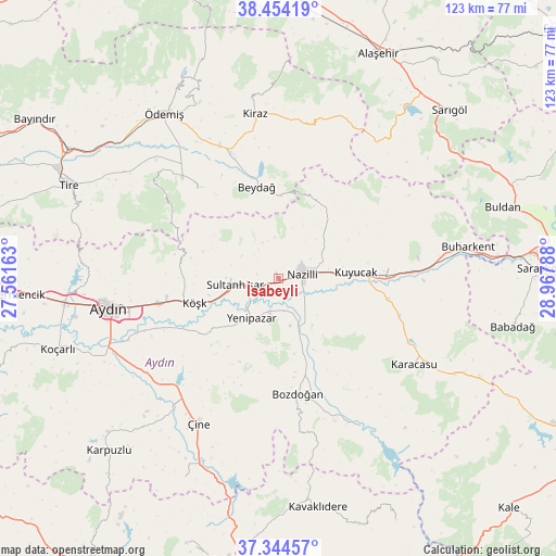
İsabeyli GPS coordinates[2]
37° 54' 5.292" North, 28° 15' 53.1" East
| Map corner | latitude | longitude |
|---|---|---|
| Upper-left | 38.45419°, | 27.56163° |
| Center: | 37.90147°, | 28.26475° |
| Lower-right: | 37.34457°, | 28.96788° |
| Map W x H: | 123.4×123.4 km | = 76.7×76.7mi |
| max Lat: | 42.02683° ⇑64.9% North |
| İsabeyli: | 37.90147° |
| min Lat: | ⇓35.1% South 35.9025° |
| min Long | İsabeyli | max Long |
| 25.90902° | 28.26475° | 44.60099° |
| W 11.5%⇐ | ⇒88.5% E |
Elevation
Elevation of İsabeyli is 85 m = 279 ft, and this is 632.4 m = 2075 ft below average elevation for this country.
| Max E: |
2682 m = 8799 ft | 83.1% |
| Avg. | 717.4 m = 2354 ft | |
| İsabeyli | 85 m = 279 ft | |
Min E: |
0 m = 0 ft | 16.9% |
See also: Turkey elevation on elevation.city.
Geographical zone
İsabeyli is located in North temperate zone (between Tropic of Cancer and the Arctic Circle). Distance of this Northern Tropic circle is 1608.3 km =999.4 mi to South.| Distance of | km | miles | from İsabeyli |
|---|---|---|---|
| North Pole | 5792.8 | 3599.5 | to North |
| Arctic Circle | 3186.9 | 1980.2 | to North |
| Tropic Cancer | 1608.3 | 999.4 | to South |
| Equator | 4214.2 | 2618.6 | to South |


Nearby cities:
15 places around İsabeyli: (largest is in red/bold)
• Atça
4.6 km =2.9 mi,  251°
251°
• Bademli
27 km =16.8 mi,  317°
317°
• Bozdoğan
26 km =16.2 mi,  170°
170°
• Dalama
21.4 km =13.3 mi,  234°
234°
• Horsunlu
28.7 km =17.8 mi,  87°
87°
• Kuyucak
17.1 km =10.6 mi, 85°
• Köşk
19.5 km =12.1 mi, 254°
• Nazilli
5.3 km =3.3 mi,  71°
71°
• Pamukören
24.4 km =15.2 mi,  84°
84°
• Salavatlı
14.2 km =8.8 mi,  265°
265°
• Sultanhisar
9.8 km =6.1 mi,  262°
262°
• Umurlu
27.1 km =16.8 mi, 257°
• Yenice
28.1 km =17.5 mi,  106°
106°
• Yenipazar
10.6 km =6.6 mi,  214°
214°
• Çaylı
29.9 km =18.6 mi,  339°
339°
Sources, notices
• [Note1] Compared only with cities in Turkey existing in our database
• [Src1] Map data: © OpenStreetMap contributors (CC-BY-SA)
• [Src2] Other city data from geonames.org with taken over terms of usage.
• [Src3] Geographical zone / Annual Mean Temperature by Robert A. Rohde @ Wikipedia
