Aydın geodata
Aydın is a seat of a first-order administrative division; located in Turkey in Europe/Istanbul (GMT+3) time zone. With population of 163,022 people, there are 59 cities with bigger population in this country. Compared to other cities in Turkey, 67.2% of cities are located further ↑North; 91.4% of cities are located further →East and 85.6% of cities have higher elevation than Aydın. Note1


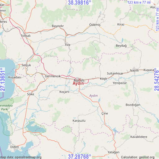
Aydın GPS coordinates[2]
37° 50' 42.036" North, 27° 50' 22.668" East
| Map corner | latitude | longitude |
|---|---|---|
| Upper-left | 38.39816°, | 27.13651° |
| Center: | 37.84501°, | 27.83963° |
| Lower-right: | 37.28768°, | 28.54276° |
| Map W x H: | 123.5×123.5 km | = 76.7×76.7mi |
| max Lat: | 42.02683° ⇑67.2% North |
| Aydın: | 37.84501° |
| min Lat: | ⇓32.8% South 35.9025° |
| min Long | Aydın | max Long |
| 25.90902° | 27.83963° | 44.60099° |
| W 8.6%⇐ | ⇒91.4% E |
Elevation
Elevation of Aydın is 67 m = 220 ft, and this is 650.4 m = 2134 ft below average elevation for this country.
| Max E: |
2682 m = 8799 ft | 85.6% |
| Avg. | 717.4 m = 2354 ft | |
| Aydın | 67 m = 220 ft | |
Min E: |
0 m = 0 ft | 14.4% |
See also: Aydın elevation on elevation.city.
Geographical zone
Aydın is located in North temperate zone (between Tropic of Cancer and the Arctic Circle). Distance of this Northern Tropic circle is 1602.1 km =995.5 mi to South.| Distance of | km | miles | from Aydın |
|---|---|---|---|
| North Pole | 5799.1 | 3603.4 | to North |
| Arctic Circle | 3193.2 | 1984.2 | to North |
| Tropic Cancer | 1602.1 | 995.5 | to South |
| Equator | 4208 | 2614.7 | to South |


Nearby cities:
15 places around Aydın: (largest is in red/bold)
• Acarlar
8.5 km =5.3 mi,  254°
254°
• Bağarası
29.8 km =18.5 mi,  239°
239°
• Dalama
20.8 km =12.9 mi,  106°
106°
• Germencik
21 km =13 mi,  277°
277°
• Gökçen
30 km =18.6 mi,  5°
5°
• Koçarlı
15 km =9.3 mi,  231°
231°
• Köşk
18.6 km =11.6 mi,  87°
87°
• Ortaklar
30 km =18.6 mi, 279°
• Salavatlı
23.7 km =14.7 mi,  77°
77°
• Sultanhisar
28.1 km =17.5 mi, 79°
• Tepecik
3.9 km =2.4 mi,  127°
127°
• Tire
28.6 km =17.8 mi,  341°
341°
• Umurlu
10.8 km =6.7 mi, 87°
• Çakırbeyli
12.3 km =7.6 mi,  186°
186°
• İncirliova
10.2 km =6.3 mi,  274°
274°
In other languages:
- In Spanish: Aydin
- In German: Tralleis
- In Italian: Tralli
- In Russian: Айдын
- In Chinese: 艾登
Sources, notices
• [Note1] Compared only with cities in Turkey existing in our database
• [Src1] Map data: © OpenStreetMap contributors (CC-BY-SA)
• [Src2] Other city data from geonames.org with taken over terms of usage.
• [Src3] Geographical zone / Annual Mean Temperature by Robert A. Rohde @ Wikipedia
