Umurlu geodata
Umurlu (Aydın) is a seat of a third-order administrative division; located in Turkey in Europe/Istanbul (GMT+3) time zone. In our database, there are 1323 cities with bigger population. Compared to other cities in Turkey, 67% of cities are located further ↑North; 90.7% of cities are located further →East and 87.9% of cities have higher elevation than Umurlu. Note1


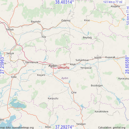
Umurlu GPS coordinates[2]
37° 51' 0.108" North, 27° 57' 45.9" East
| Map corner | latitude | longitude |
|---|---|---|
| Upper-left | 38.40314°, | 27.25963° |
| Center: | 37.85003°, | 27.96275° |
| Lower-right: | 37.29274°, | 28.66588° |
| Map W x H: | 123.5×123.5 km | = 76.7×76.7mi |
| max Lat: | 42.02683° ⇑67% North |
| Umurlu: | 37.85003° |
| min Lat: | ⇓33% South 35.9025° |
| min Long | Umurlu | max Long |
| 25.90902° | 27.96275° | 44.60099° |
| W 9.3%⇐ | ⇒90.7% E |
Elevation
Elevation of Umurlu is 52 m = 171 ft, and this is 665.4 m = 2183 ft below average elevation for this country.
| Max E: |
2682 m = 8799 ft | 87.9% |
| Avg. | 717.4 m = 2354 ft | |
| Umurlu | 52 m = 171 ft | |
Min E: |
0 m = 0 ft | 12.1% |
See also: Turkey elevation on elevation.city.
Geographical zone
Umurlu is located in North temperate zone (between Tropic of Cancer and the Arctic Circle). Distance of this Northern Tropic circle is 1602.6 km =995.8 mi to South.| Distance of | km | miles | from Umurlu |
|---|---|---|---|
| North Pole | 5798.5 | 3603 | to North |
| Arctic Circle | 3192.6 | 1983.8 | to North |
| Tropic Cancer | 1602.6 | 995.8 | to South |
| Equator | 4208.5 | 2615 | to South |


Nearby cities:
15 places around Umurlu: (largest is in red/bold)
• Acarlar
19.2 km =11.9 mi,  261°
261°
• Atça
22.6 km =14 mi,  79°
79°
• Aydın
10.8 km =6.7 mi,  267°
267°
• Bademli
27.1 km =16.8 mi,  17°
17°
• Dalama
11.3 km =7 mi,  126°
126°
• Koçarlı
24.6 km =15.3 mi,  246°
246°
• Köşk
7.8 km =4.8 mi,  87°
87°
• Salavatlı
13.2 km =8.2 mi,  69°
69°
• Sultanhisar
17.4 km =10.8 mi, 75°
• Tepecik
8.3 km =5.2 mi, 249°
• Yenipazar
20.7 km =12.9 mi,  98°
98°
• Çakırbeyli
17.7 km =11 mi,  223°
223°
• Çine
27.7 km =17.2 mi,  162°
162°
• İncirliova
21 km =13 mi, 270°
• İsabeyli
27.1 km =16.8 mi, 77°
Sources, notices
• [Note1] Compared only with cities in Turkey existing in our database
• [Src1] Map data: © OpenStreetMap contributors (CC-BY-SA)
• [Src2] Other city data from geonames.org with taken over terms of usage.
• [Src3] Geographical zone / Annual Mean Temperature by Robert A. Rohde @ Wikipedia
