Söğütlü geodata
Söğütlü (Bingöl) is a seat of a second-order administrative division; located in Turkey in Europe/Istanbul (GMT+3) time zone. In our database, there are 1323 cities with bigger population. Compared to other cities in Turkey, 51.9% of cities are located further ↓South; 77.9% of cities are located further ←West and 80.5% of cities have lower elevation than Söğütlü. Note1


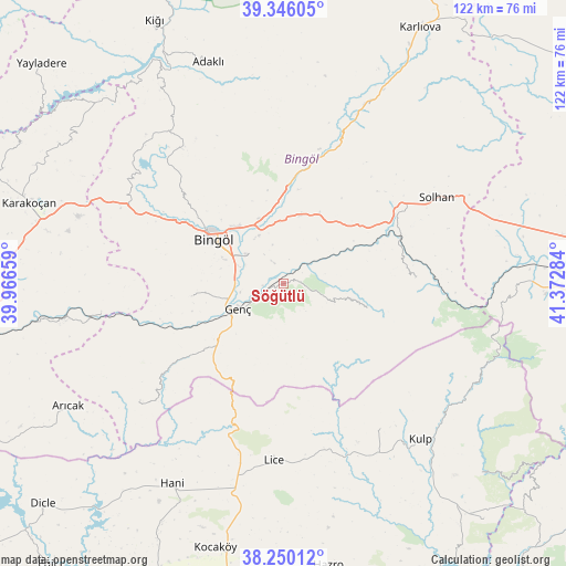
Söğütlü GPS coordinates[2]
38° 48' 0.684" North, 40° 40' 10.956" East
| Map corner | latitude | longitude |
|---|---|---|
| Upper-left | 39.34605°, | 39.96659° |
| Center: | 38.80019°, | 40.66971° |
| Lower-right: | 38.25012°, | 41.37284° |
| Map W x H: | 121.9×121.9 km | = 75.7×75.7mi |
| max Lat: | 42.02683° ⇑48.1% North |
| Söğütlü: | 38.80019° |
| min Lat: | ⇓51.9% South 35.9025° |
| min Long | Söğütlü | max Long |
| 25.90902° | 40.66971° | 44.60099° |
| W 77.9%⇐ | ⇒22.1% E |
Elevation
Elevation of Söğütlü is 1204 m = 3950 ft, and this is 486.6 m = 1596 ft above average elevation for this country.
| Max E: |
2682 m = 8799 ft | 19.5% |
| Söğütlü | 1204 m 3950 ft | |
| Avg. | 717.4 m = 2354 ft | |
Min E: |
0 m = 0 ft | 80.5% |
See also: Turkey elevation on elevation.city.
Geographical zone
Söğütlü is located in North temperate zone (between Tropic of Cancer and the Arctic Circle). Distance of this Northern Tropic circle is 1708.3 km =1061.5 mi to South.| Distance of | km | miles | from Söğütlü |
|---|---|---|---|
| North Pole | 5692.9 | 3537.4 | to North |
| Arctic Circle | 3087 | 1918.2 | to North |
| Tropic Cancer | 1708.3 | 1061.5 | to South |
| Equator | 4314.2 | 2680.7 | to South |


Nearby cities:
15 places around Söğütlü: (largest is in red/bold)
• Ağaçlı
37.5 km =23.3 mi,  147°
147°
• Bingöl
17.9 km =11.1 mi,  301°
301°
• Genç
11.6 km =7.2 mi,  239°
239°
• Gökdere
40.5 km =25.2 mi,  260°
260°
• Göynük
41.7 km =25.9 mi,  25°
25°
• Ilıcalar
20 km =12.4 mi,  1°
1°
• Kulp
44.6 km =27.7 mi,  138°
138°
• Lice
38.1 km =23.7 mi,  184°
184°
• Sancak
40.6 km =25.2 mi,  323°
323°
• Servi
39.7 km =24.7 mi,  229°
229°
• Solhan
38 km =23.6 mi,  61°
61°
• Yamaç
20.2 km =12.6 mi, 262°
• Yayla
22.5 km =14 mi,  213°
213°
• Yenibaşak
27.9 km =17.3 mi,  89°
89°
• Yenisu
18.6 km =11.6 mi,  106°
106°
Sources, notices
• [Note1] Compared only with cities in Turkey existing in our database
• [Src1] Map data: © OpenStreetMap contributors (CC-BY-SA)
• [Src2] Other city data from geonames.org with taken over terms of usage.
• [Src3] Geographical zone / Annual Mean Temperature by Robert A. Rohde @ Wikipedia
