Bingöl geodata
Bingöl is a seat of a first-order administrative division; located in Turkey in Europe/Istanbul (GMT+3) time zone. With population of 80,568 people, there are 113 cities with bigger population in this country. Compared to other cities in Turkey, 53% of cities are located further ↓South; 76.2% of cities are located further ←West and 78.1% of cities have lower elevation than Bingöl. Note1


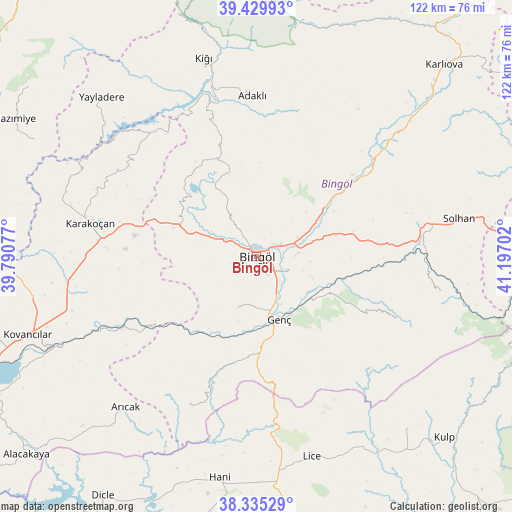
Bingöl GPS coordinates[2]
38° 53' 4.992" North, 40° 29' 38.004" East
| Map corner | latitude | longitude |
|---|---|---|
| Upper-left | 39.42993°, | 39.79077° |
| Center: | 38.88472°, | 40.49389° |
| Lower-right: | 38.33529°, | 41.19702° |
| Map W x H: | 121.7×121.7 km | = 75.6×75.6mi |
| max Lat: | 42.02683° ⇑47% North |
| Bingöl: | 38.88472° |
| min Lat: | ⇓53% South 35.9025° |
| min Long | Bingöl | max Long |
| 25.90902° | 40.49389° | 44.60099° |
| W 76.2%⇐ | ⇒23.8% E |
Elevation
Elevation of Bingöl is 1158 m = 3799 ft, and this is 440.6 m = 1446 ft above average elevation for this country.
| Max E: |
2682 m = 8799 ft | 21.9% |
| Bingöl | 1158 m 3799 ft | |
| Avg. | 717.4 m = 2354 ft | |
Min E: |
0 m = 0 ft | 78.1% |
See also: Bingöl elevation on elevation.city.
Geographical zone
Bingöl is located in North temperate zone (between Tropic of Cancer and the Arctic Circle). Distance of this Northern Tropic circle is 1717.7 km =1067.3 mi to South.| Distance of | km | miles | from Bingöl |
|---|---|---|---|
| North Pole | 5683.5 | 3531.6 | to North |
| Arctic Circle | 3077.6 | 1912.3 | to North |
| Tropic Cancer | 1717.7 | 1067.3 | to South |
| Equator | 4323.6 | 2686.6 | to South |


Nearby cities:
15 places around Bingöl: (largest is in red/bold)
• Adaklı
38 km =23.6 mi,  358°
358°
• Başyurt
44.9 km =27.9 mi,  262°
262°
• Genç
16.1 km =10 mi,  161°
161°
• Gökdere
29.4 km =18.3 mi,  237°
237°
• Göynük
43.4 km =27 mi,  49°
49°
• Ilıcalar
18.9 km =11.7 mi,  55°
55°
• Karakoçan
41.1 km =25.5 mi,  280°
280°
• Sancak
24.8 km =15.4 mi,  338°
338°
• Servi
38.1 km =23.7 mi,  203°
203°
• Söğütlü
17.9 km =11.1 mi,  121°
121°
• Yamaç
13 km =8.1 mi, 201°
• Yayla
28.4 km =17.6 mi,  174°
174°
• Yenibaşak
44.1 km =27.4 mi,  101°
101°
• Yenisu
36.2 km =22.5 mi,  114°
114°
• Çan
38.6 km =24 mi,  319°
319°
Sources, notices
• [Note1] Compared only with cities in Turkey existing in our database
• [Src1] Map data: © OpenStreetMap contributors (CC-BY-SA)
• [Src2] Other city data from geonames.org with taken over terms of usage.
• [Src3] Geographical zone / Annual Mean Temperature by Robert A. Rohde @ Wikipedia
