Genç geodata
Genç (Bingöl) is a seat of a second-order administrative division; located in Turkey in Europe/Istanbul (GMT+3) time zone. With population of 22,493 people, there are 308 cities with bigger population in this country. Compared to other cities in Turkey, 51.1% of cities are located further ↓South; 76.8% of cities are located further ←West and 69.1% of cities have lower elevation than Genç. Note1


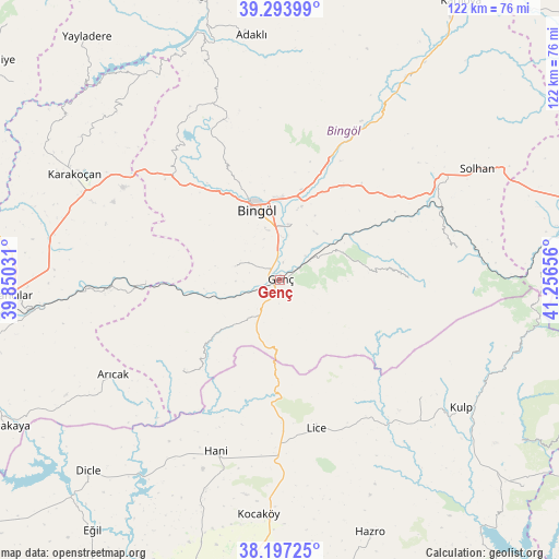
Genç GPS coordinates[2]
38° 44' 51.828" North, 40° 33' 12.348" East
| Map corner | latitude | longitude |
|---|---|---|
| Upper-left | 39.29399°, | 39.85031° |
| Center: | 38.74773°, | 40.55343° |
| Lower-right: | 38.19725°, | 41.25656° |
| Map W x H: | 121.9×121.9 km | = 75.7×75.7mi |
| max Lat: | 42.02683° ⇑48.9% North |
| Genç: | 38.74773° |
| min Lat: | ⇓51.1% South 35.9025° |
| min Long | Genç | max Long |
| 25.90902° | 40.55343° | 44.60099° |
| W 76.8%⇐ | ⇒23.2% E |
Elevation
Elevation of Genç is 1015 m = 3330 ft, and this is 297.6 m = 976 ft above average elevation for this country.
| Max E: |
2682 m = 8799 ft | 30.9% |
| Genç | 1015 m 3330 ft | |
| Avg. | 717.4 m = 2354 ft | |
Min E: |
0 m = 0 ft | 69.1% |
See also: Turkey elevation on elevation.city.
Geographical zone
Genç is located in North temperate zone (between Tropic of Cancer and the Arctic Circle). Distance of this Northern Tropic circle is 1702.4 km =1057.8 mi to South.| Distance of | km | miles | from Genç |
|---|---|---|---|
| North Pole | 5698.7 | 3541 | to North |
| Arctic Circle | 3092.8 | 1921.8 | to North |
| Tropic Cancer | 1702.4 | 1057.8 | to South |
| Equator | 4308.3 | 2677.1 | to South |


Nearby cities:
15 places around Genç: (largest is in red/bold)
• Arıcak
42.5 km =26.4 mi,  241°
241°
• Ağaçlı
39.8 km =24.7 mi,  130°
130°
• Bingöl
16.1 km =10 mi,  341°
341°
• Gökdere
29.9 km =18.6 mi,  268°
268°
• Hani
40.5 km =25.2 mi,  201°
201°
• Ilıcalar
27.9 km =17.3 mi,  21°
21°
• Kayacık
45.5 km =28.3 mi,  173°
173°
• Lice
33 km =20.5 mi, 167°
• Sancak
40.9 km =25.4 mi, 339°
• Servi
28.3 km =17.6 mi,  225°
225°
• Söğütlü
11.6 km =7.2 mi,  59°
59°
• Yamaç
10.4 km =6.5 mi,  287°
287°
• Yayla
13.2 km =8.2 mi,  189°
189°
• Yenibaşak
38.5 km =23.9 mi,  80°
80°
• Yenisu
28 km =17.4 mi,  89°
89°
Sources, notices
• [Note1] Compared only with cities in Turkey existing in our database
• [Src1] Map data: © OpenStreetMap contributors (CC-BY-SA)
• [Src2] Other city data from geonames.org with taken over terms of usage.
• [Src3] Geographical zone / Annual Mean Temperature by Robert A. Rohde @ Wikipedia
