Yayla geodata
Yayla (Bingöl) is a seat of a third-order administrative division; located in Turkey in Europe/Istanbul (GMT+3) time zone. In our database, there are 1323 cities with bigger population. Compared to other cities in Turkey, 51.1% of cities are located further ↑North; 76.5% of cities are located further ←West and 85% of cities have lower elevation than Yayla. Note1


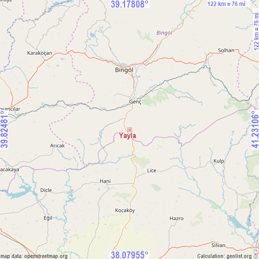
Yayla GPS coordinates[2]
38° 37' 51.312" North, 40° 31' 40.548" East
| Map corner | latitude | longitude |
|---|---|---|
| Upper-left | 39.17808°, | 39.82481° |
| Center: | 38.63092°, | 40.52793° |
| Lower-right: | 38.07955°, | 41.23106° |
| Map W x H: | 122.1×122.1 km | = 75.9×75.9mi |
| max Lat: | 42.02683° ⇑51.1% North |
| Yayla: | 38.63092° |
| min Lat: | ⇓48.9% South 35.9025° |
| min Long | Yayla | max Long |
| 25.90902° | 40.52793° | 44.60099° |
| W 76.5%⇐ | ⇒23.5% E |
Elevation
Elevation of Yayla is 1308 m = 4291 ft, and this is 590.6 m = 1938 ft above average elevation for this country.
| Max E: |
2682 m = 8799 ft | 15% |
| Yayla | 1308 m 4291 ft | |
| Avg. | 717.4 m = 2354 ft | |
Min E: |
0 m = 0 ft | 85% |
See also: Turkey elevation on elevation.city.
Geographical zone
Yayla is located in North temperate zone (between Tropic of Cancer and the Arctic Circle). Distance of this Northern Tropic circle is 1689.4 km =1049.7 mi to South.| Distance of | km | miles | from Yayla |
|---|---|---|---|
| North Pole | 5711.7 | 3549.1 | to North |
| Arctic Circle | 3105.8 | 1929.9 | to North |
| Tropic Cancer | 1689.4 | 1049.7 | to South |
| Equator | 4295.4 | 2669 | to South |


Nearby cities:
15 places around Yayla: (largest is in red/bold)
• Arıcak
35.8 km =22.2 mi,  257°
257°
• Ağaçlı
35 km =21.7 mi,  111°
111°
• Bingöl
28.4 km =17.6 mi,  354°
354°
• Genç
13.2 km =8.2 mi,  9°
9°
• Gökdere
30.4 km =18.9 mi,  294°
294°
• Hani
27.8 km =17.3 mi,  206°
206°
• Ilıcalar
40.9 km =25.4 mi,  18°
18°
• Kayacık
33 km =20.5 mi,  166°
166°
• Kocaköy
38.1 km =23.7 mi,  183°
183°
• Kulp
44.2 km =27.5 mi, 109°
• Lice
21.5 km =13.4 mi,  153°
153°
• Servi
19.3 km =12 mi,  249°
249°
• Söğütlü
22.5 km =14 mi,  33°
33°
• Yamaç
17.9 km =11.1 mi,  334°
334°
• Yenisu
33 km =20.5 mi,  65°
65°
Sources, notices
• [Note1] Compared only with cities in Turkey existing in our database
• [Src1] Map data: © OpenStreetMap contributors (CC-BY-SA)
• [Src2] Other city data from geonames.org with taken over terms of usage.
• [Src3] Geographical zone / Annual Mean Temperature by Robert A. Rohde @ Wikipedia
