Serik geodata
Serik (Antalya) is a seat of a second-order administrative division; located in Turkey in Europe/Istanbul (GMT+3) time zone. With population of 36,925 people, there are 215 cities with bigger population in this country. Compared to other cities in Turkey, 90.4% of cities are located further ↑North; 70.2% of cities are located further →East and 92.2% of cities have higher elevation than Serik. Note1


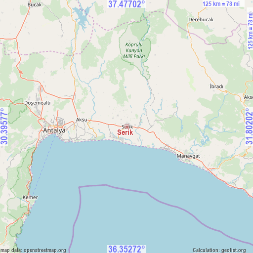
Serik GPS coordinates[2]
36° 55' 0.984" North, 31° 5' 56.004" East
| Map corner | latitude | longitude |
|---|---|---|
| Upper-left | 37.47702°, | 30.39577° |
| Center: | 36.91694°, | 31.09889° |
| Lower-right: | 36.35272°, | 31.80202° |
| Map W x H: | 125×125 km | = 77.7×77.7mi |
| max Lat: | 42.02683° ⇑90.4% North |
| Serik: | 36.91694° |
| min Lat: | ⇓9.6% South 35.9025° |
| min Long | Serik | max Long |
| 25.90902° | 31.09889° | 44.60099° |
| W 29.8%⇐ | ⇒70.2% E |
Elevation
Elevation of Serik is 28 m = 92 ft, and this is 689.4 m = 2262 ft below average elevation for this country.
| Max E: |
2682 m = 8799 ft | 92.2% |
| Avg. | 717.4 m = 2354 ft | |
| Serik | 28 m = 92 ft | |
Min E: |
0 m = 0 ft | 7.8% |
See also: Turkey elevation on elevation.city.
Geographical zone
Serik is located in North temperate zone (between Tropic of Cancer and the Arctic Circle). Distance of this Northern Tropic circle is 1498.9 km =931.4 mi to South.| Distance of | km | miles | from Serik |
|---|---|---|---|
| North Pole | 5902.3 | 3667.5 | to North |
| Arctic Circle | 3296.4 | 2048.3 | to North |
| Tropic Cancer | 1498.9 | 931.4 | to South |
| Equator | 4104.8 | 2550.6 | to South |


Nearby cities:
15 places around Serik: (largest is in red/bold)
• Aksu
22.7 km =14.1 mi,  280°
280°
• Antalya
35.9 km =22.3 mi,  268°
268°
• Belek
7.1 km =4.4 mi,  212°
212°
• Beşkonak
26.8 km =16.7 mi,  19°
19°
• Boğazkent
9.1 km =5.7 mi,  140°
140°
• Büyükbelkis
6.8 km =4.2 mi,  62°
62°
• Evrenseki
24.4 km =15.2 mi,  110°
110°
• Gebiz
25.3 km =15.7 mi,  325°
325°
• Kepez
34.8 km =21.6 mi, 269°
• Konyaaltı
42 km =26.1 mi,  262°
262°
• Kumköy
13.6 km =8.5 mi,  253°
253°
• Manavgat
33.9 km =21.1 mi,  115°
115°
• Muratpaşa
29.8 km =18.5 mi, 264°
• Side
30.7 km =19.1 mi, 122°
• Taşağıl
12.2 km =7.6 mi,  87°
87°
Sources, notices
• [Note1] Compared only with cities in Turkey existing in our database
• [Src1] Map data: © OpenStreetMap contributors (CC-BY-SA)
• [Src2] Other city data from geonames.org with taken over terms of usage.
• [Src3] Geographical zone / Annual Mean Temperature by Robert A. Rohde @ Wikipedia
