Taşağıl geodata
Taşağıl (Antalya) is a seat of a third-order administrative division; located in Turkey in Europe/Istanbul (GMT+3) time zone. In our database, there are 1323 cities with bigger population. Compared to other cities in Turkey, 90.1% of cities are located further ↑North; 69.5% of cities are located further →East and 82.9% of cities have higher elevation than Taşağıl. Note1


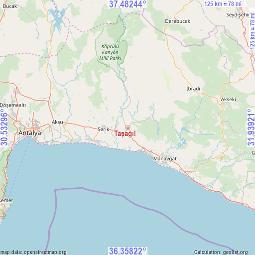
Taşağıl GPS coordinates[2]
36° 55' 20.64" North, 31° 14' 9.888" East
| Map corner | latitude | longitude |
|---|---|---|
| Upper-left | 37.48244°, | 30.53296° |
| Center: | 36.9224°, | 31.23608° |
| Lower-right: | 36.35822°, | 31.93921° |
| Map W x H: | 125×125 km | = 77.7×77.7mi |
| max Lat: | 42.02683° ⇑90.1% North |
| Taşağıl: | 36.9224° |
| min Lat: | ⇓9.9% South 35.9025° |
| min Long | Taşağıl | max Long |
| 25.90902° | 31.23608° | 44.60099° |
| W 30.5%⇐ | ⇒69.5% E |
Elevation
Elevation of Taşağıl is 86 m = 282 ft, and this is 631.4 m = 2072 ft below average elevation for this country.
| Max E: |
2682 m = 8799 ft | 82.9% |
| Avg. | 717.4 m = 2354 ft | |
| Taşağıl | 86 m = 282 ft | |
Min E: |
0 m = 0 ft | 17.1% |
See also: Turkey elevation on elevation.city.
Geographical zone
Taşağıl is located in North temperate zone (between Tropic of Cancer and the Arctic Circle). Distance of this Northern Tropic circle is 1499.5 km =931.7 mi to South.| Distance of | km | miles | from Taşağıl |
|---|---|---|---|
| North Pole | 5901.7 | 3667.1 | to North |
| Arctic Circle | 3295.8 | 2047.9 | to North |
| Tropic Cancer | 1499.5 | 931.7 | to South |
| Equator | 4105.4 | 2551 | to South |


Nearby cities:
15 places around Taşağıl: (largest is in red/bold)
• Aksu
34.7 km =21.6 mi,  275°
275°
• Belek
17.4 km =10.8 mi,  247°
247°
• Beşkonak
24.9 km =15.5 mi,  352°
352°
• Boğazkent
10 km =6.2 mi,  219°
219°
• Büyükbelkis
6.6 km =4.1 mi,  291°
291°
• Evrenseki
14.1 km =8.8 mi,  131°
131°
• Gebiz
33.3 km =20.7 mi,  307°
307°
• Geriş
44.4 km =27.6 mi,  84°
84°
• Kumköy
25.7 km =16 mi,  260°
260°
• Kızılağaç
34.1 km =21.2 mi, 128°
• Manavgat
23.8 km =14.8 mi, 129°
• Muratpaşa
42 km =26.1 mi,  265°
265°
• Serik
12.2 km =7.6 mi, 267°
• Side
22 km =13.7 mi,  141°
141°
• İbradı
37.6 km =23.4 mi,  58°
58°
Sources, notices
• [Note1] Compared only with cities in Turkey existing in our database
• [Src1] Map data: © OpenStreetMap contributors (CC-BY-SA)
• [Src2] Other city data from geonames.org with taken over terms of usage.
• [Src3] Geographical zone / Annual Mean Temperature by Robert A. Rohde @ Wikipedia
