Kumköy geodata
Kumköy (Antalya) is a populated place; located in Turkey in Europe/Istanbul (GMT+3) time zone. With population of 1,074 people, there are 1074 cities with bigger population in this country. Compared to other cities in Turkey, 91.1% of cities are located further ↑North; 70.8% of cities are located further →East and 99.8% of cities have higher elevation than Kumköy. Note1


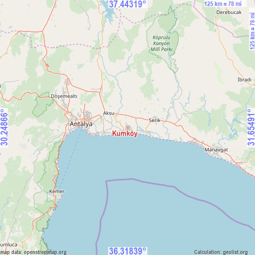
Kumköy GPS coordinates[2]
36° 52' 58.296" North, 30° 57' 6.408" East
| Map corner | latitude | longitude |
|---|---|---|
| Upper-left | 37.44319°, | 30.24866° |
| Center: | 36.88286°, | 30.95178° |
| Lower-right: | 36.31839°, | 31.65491° |
| Map W x H: | 125.1×125.1 km | = 77.7×77.7mi |
| max Lat: | 42.02683° ⇑91.1% North |
| Kumköy: | 36.88286° |
| min Lat: | ⇓8.9% South 35.9025° |
| min Long | Kumköy | max Long |
| 25.90902° | 30.95178° | 44.60099° |
| W 29.2%⇐ | ⇒70.8% E |
Elevation
Elevation of Kumköy is 3 m = 10 ft, and this is 714.4 m = 2344 ft below average elevation for this country.
| Max E: |
2682 m = 8799 ft | 99.8% |
| Avg. | 717.4 m = 2354 ft | |
| Kumköy | 3 m = 10 ft | |
Min E: |
0 m = 0 ft | 0.2% |
See also: Turkey elevation on elevation.city.
Geographical zone
Kumköy is located in North temperate zone (between Tropic of Cancer and the Arctic Circle). Distance of this Northern Tropic circle is 1495.1 km =929 mi to South.| Distance of | km | miles | from Kumköy |
|---|---|---|---|
| North Pole | 5906.1 | 3669.9 | to North |
| Arctic Circle | 3300.2 | 2050.6 | to North |
| Tropic Cancer | 1495.1 | 929 | to South |
| Equator | 4101 | 2548.2 | to South |


Nearby cities:
15 places around Kumköy: (largest is in red/bold)
• Aksu
12.2 km =7.6 mi,  310°
310°
• Antalya
23 km =14.3 mi,  277°
277°
• Belek
9.5 km =5.9 mi,  103°
103°
• Beşkonak
36.4 km =22.6 mi,  37°
37°
• Boğazkent
19.2 km =11.9 mi, 99°
• Büyükbelkis
20.3 km =12.6 mi,  70°
70°
• Döşemealtı
34.7 km =21.6 mi,  296°
296°
• Evrenseki
36.3 km =22.6 mi, 97°
• Gebiz
24.6 km =15.3 mi,  357°
357°
• Kepez
22 km =13.7 mi, 279°
• Konyaaltı
28.7 km =17.8 mi,  266°
266°
• Muratpaşa
16.6 km =10.3 mi, 273°
• Serik
13.6 km =8.5 mi, 73°
• Taşağıl
25.7 km =16 mi,  80°
80°
• Çakırlar
34.7 km =21.6 mi, 267°
Sources, notices
• [Note1] Compared only with cities in Turkey existing in our database
• [Src1] Map data: © OpenStreetMap contributors (CC-BY-SA)
• [Src2] Other city data from geonames.org with taken over terms of usage.
• [Src3] Geographical zone / Annual Mean Temperature by Robert A. Rohde @ Wikipedia
