Konyaaltı geodata
Konyaaltı (Antalya) is a seat of a second-order administrative division; located in Turkey in Europe/Istanbul (GMT+3) time zone. In our database, there are 1323 cities with bigger population. Compared to other cities in Turkey, 91.5% of cities are located further ↑North; 72.1% of cities are located further →East and 95.5% of cities have higher elevation than Konyaaltı. Note1


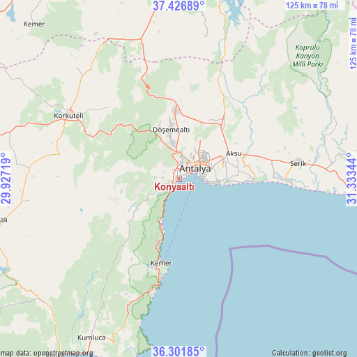
Konyaaltı GPS coordinates[2]
36° 51' 59.184" North, 30° 37' 49.116" East
| Map corner | latitude | longitude |
|---|---|---|
| Upper-left | 37.42689°, | 29.92719° |
| Center: | 36.86644°, | 30.63031° |
| Lower-right: | 36.30185°, | 31.33344° |
| Map W x H: | 125.1×125.1 km | = 77.7×77.7mi |
| max Lat: | 42.02683° ⇑91.5% North |
| Konyaaltı: | 36.86644° |
| min Lat: | ⇓8.5% South 35.9025° |
| min Long | Konyaaltı | max Long |
| 25.90902° | 30.63031° | 44.60099° |
| W 27.9%⇐ | ⇒72.1% E |
Elevation
Elevation of Konyaaltı is 15 m = 49 ft, and this is 702.4 m = 2304 ft below average elevation for this country.
| Max E: |
2682 m = 8799 ft | 95.5% |
| Avg. | 717.4 m = 2354 ft | |
| Konyaaltı | 15 m = 49 ft | |
Min E: |
0 m = 0 ft | 4.5% |
See also: Turkey elevation on elevation.city.
Geographical zone
Konyaaltı is located in North temperate zone (between Tropic of Cancer and the Arctic Circle). Distance of this Northern Tropic circle is 1493.2 km =927.8 mi to South.| Distance of | km | miles | from Konyaaltı |
|---|---|---|---|
| North Pole | 5907.9 | 3671 | to North |
| Arctic Circle | 3302 | 2051.8 | to North |
| Tropic Cancer | 1493.2 | 927.8 | to South |
| Equator | 4099.2 | 2547.1 | to South |


Nearby cities:
15 places around Konyaaltı: (largest is in red/bold)
• Aksu
21.6 km =13.4 mi,  63°
63°
• Antalya
7.4 km =4.6 mi,  51°
51°
• Belek
37.8 km =23.5 mi,  90°
90°
• Dağ
38 km =23.6 mi,  342°
342°
• Döşemealtı
17.6 km =10.9 mi,  351°
351°
• Gebiz
38 km =23.6 mi, 45°
• Geyikbayırı
15.3 km =9.5 mi,  273°
273°
• Göynük
24 km =14.9 mi,  197°
197°
• Kemer
30.5 km =19 mi,  191°
191°
• Kepez
8.8 km =5.5 mi, 51°
• Kumköy
28.7 km =17.8 mi, 86°
• Muratpaşa
12.3 km =7.6 mi,  76°
76°
• Serik
42 km =26.1 mi, 82°
• Tekirova
41.6 km =25.8 mi, 192°
• Çakırlar
6.1 km =3.8 mi,  275°
275°
Sources, notices
• [Note1] Compared only with cities in Turkey existing in our database
• [Src1] Map data: © OpenStreetMap contributors (CC-BY-SA)
• [Src2] Other city data from geonames.org with taken over terms of usage.
• [Src3] Geographical zone / Annual Mean Temperature by Robert A. Rohde @ Wikipedia
