Büyükbelkis geodata
Büyükbelkis (Antalya) is a populated place; located in Turkey in Europe/Istanbul (GMT+3) time zone. With population of 1,000 people, there are 1091 cities with bigger population in this country. Compared to other cities in Turkey, 89.7% of cities are located further ↑North; 69.9% of cities are located further →East and 92.9% of cities have higher elevation than Büyükbelkis. Note1


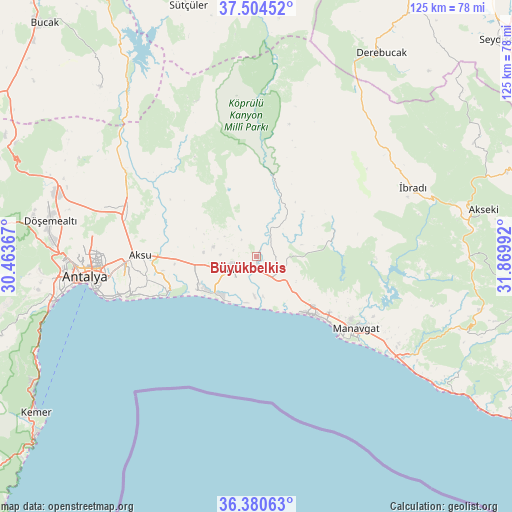
Büyükbelkis GPS coordinates[2]
36° 56' 40.74" North, 31° 10' 0.444" East
| Map corner | latitude | longitude |
|---|---|---|
| Upper-left | 37.50452°, | 30.46367° |
| Center: | 36.94465°, | 31.16679° |
| Lower-right: | 36.38063°, | 31.86992° |
| Map W x H: | 125×125 km | = 77.7×77.7mi |
| max Lat: | 42.02683° ⇑89.7% North |
| Büyükbelkis: | 36.94465° |
| min Lat: | ⇓10.3% South 35.9025° |
| min Long | Büyükbelkis | max Long |
| 25.90902° | 31.16679° | 44.60099° |
| W 30.1%⇐ | ⇒69.9% E |
Elevation
Elevation of Büyükbelkis is 25 m = 82 ft, and this is 692.4 m = 2272 ft below average elevation for this country.
| Max E: |
2682 m = 8799 ft | 92.9% |
| Avg. | 717.4 m = 2354 ft | |
| Büyükbelkis | 25 m = 82 ft | |
Min E: |
0 m = 0 ft | 7.1% |
See also: Turkey elevation on elevation.city.
Geographical zone
Büyükbelkis is located in North temperate zone (between Tropic of Cancer and the Arctic Circle). Distance of this Northern Tropic circle is 1501.9 km =933.2 mi to South.| Distance of | km | miles | from Büyükbelkis |
|---|---|---|---|
| North Pole | 5899.2 | 3665.6 | to North |
| Arctic Circle | 3293.3 | 2046.4 | to North |
| Tropic Cancer | 1501.9 | 933.2 | to South |
| Equator | 4107.9 | 2552.5 | to South |


Nearby cities:
15 places around Büyükbelkis: (largest is in red/bold)
• Aksu
28.4 km =17.6 mi,  272°
272°
• Belek
13.4 km =8.3 mi,  227°
227°
• Beşkonak
22.4 km =13.9 mi,  7°
7°
• Boğazkent
10.2 km =6.3 mi,  181°
181°
• Evrenseki
20.5 km =12.7 mi,  125°
125°
• Gebiz
27 km =16.8 mi,  311°
311°
• Kepez
40.9 km =25.4 mi, 265°
• Kumköy
20.3 km =12.6 mi,  250°
250°
• Kızılağaç
40.5 km =25.2 mi, 125°
• Manavgat
30.2 km =18.8 mi, 125°
• Muratpaşa
36.2 km =22.5 mi,  260°
260°
• Serik
6.8 km =4.2 mi,  242°
242°
• Side
28 km =17.4 mi,  135°
135°
• Taşağıl
6.6 km =4.1 mi,  111°
111°
• İbradı
42 km =26.1 mi,  66°
66°
Sources, notices
• [Note1] Compared only with cities in Turkey existing in our database
• [Src1] Map data: © OpenStreetMap contributors (CC-BY-SA)
• [Src2] Other city data from geonames.org with taken over terms of usage.
• [Src3] Geographical zone / Annual Mean Temperature by Robert A. Rohde @ Wikipedia
