Pınarlar geodata
Pınarlar (Tunceli) is a seat of a third-order administrative division; located in Turkey in Europe/Istanbul (GMT+3) time zone. In our database, there are 1323 cities with bigger population. Compared to other cities in Turkey, 52.8% of cities are located further ↓South; 71% of cities are located further ←West and 83.8% of cities have lower elevation than Pınarlar. Note1


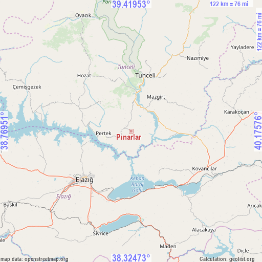
Pınarlar GPS coordinates[2]
38° 52' 27.264" North, 39° 28' 21.468" East
| Map corner | latitude | longitude |
|---|---|---|
| Upper-left | 39.41953°, | 38.76951° |
| Center: | 38.87424°, | 39.47263° |
| Lower-right: | 38.32473°, | 40.17576° |
| Map W x H: | 121.7×121.7 km | = 75.6×75.6mi |
| max Lat: | 42.02683° ⇑47.2% North |
| Pınarlar: | 38.87424° |
| min Lat: | ⇓52.8% South 35.9025° |
| min Long | Pınarlar | max Long |
| 25.90902° | 39.47263° | 44.60099° |
| W 71%⇐ | ⇒29% E |
Elevation
Elevation of Pınarlar is 1282 m = 4206 ft, and this is 564.6 m = 1852 ft above average elevation for this country.
| Max E: |
2682 m = 8799 ft | 16.2% |
| Pınarlar | 1282 m 4206 ft | |
| Avg. | 717.4 m = 2354 ft | |
Min E: |
0 m = 0 ft | 83.8% |
See also: Turkey elevation on elevation.city.
Geographical zone
Pınarlar is located in North temperate zone (between Tropic of Cancer and the Arctic Circle). Distance of this Northern Tropic circle is 1716.5 km =1066.6 mi to South.| Distance of | km | miles | from Pınarlar |
|---|---|---|---|
| North Pole | 5684.7 | 3532.3 | to North |
| Arctic Circle | 3078.8 | 1913.1 | to North |
| Tropic Cancer | 1716.5 | 1066.6 | to South |
| Equator | 4322.4 | 2685.8 | to South |


Nearby cities:
15 places around Pınarlar: (largest is in red/bold)
• Akpazar
17.2 km =10.7 mi,  100°
100°
• Darıkent
30.6 km =19 mi,  71°
71°
• Dere
19.2 km =11.9 mi,  309°
309°
• Elazığ
31 km =19.3 mi,  224°
224°
• Harput
27.6 km =17.1 mi,  226°
226°
• Hozat
34 km =21.1 mi,  317°
317°
• Kocakoç
31.4 km =19.5 mi,  30°
30°
• Mazgirt
19.4 km =12.1 mi, 34°
• Pertek
13 km =8.1 mi,  265°
265°
• Sütlüce
32.6 km =20.3 mi,  10°
10°
• Tunceli
25.8 km =16 mi, 13°
• Çaybağı
13 km =8.1 mi,  113°
113°
• Çaybağı
23.8 km =14.8 mi,  147°
147°
• Çiçekli
20.7 km =12.9 mi,  346°
346°
• İçme
29.9 km =18.6 mi,  166°
166°
Sources, notices
• [Note1] Compared only with cities in Turkey existing in our database
• [Src1] Map data: © OpenStreetMap contributors (CC-BY-SA)
• [Src2] Other city data from geonames.org with taken over terms of usage.
• [Src3] Geographical zone / Annual Mean Temperature by Robert A. Rohde @ Wikipedia
