Tunceli geodata
Tunceli is a seat of a first-order administrative division; located in Turkey in Europe/Istanbul (GMT+3) time zone. With population of 29,062 people, there are 259 cities with bigger population in this country. Compared to other cities in Turkey, 56% of cities are located further ↓South; 71.3% of cities are located further ←West and 61.4% of cities have lower elevation than Tunceli. Note1


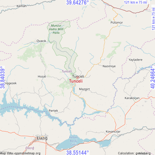
Tunceli GPS coordinates[2]
39° 5' 57.156" North, 39° 32' 36.636" East
| Map corner | latitude | longitude |
|---|---|---|
| Upper-left | 39.64276°, | 38.84039° |
| Center: | 39.09921°, | 39.54351° |
| Lower-right: | 38.55144°, | 40.24664° |
| Map W x H: | 121.3×121.3 km | = 75.4×75.4mi |
| max Lat: | 42.02683° ⇑44% North |
| Tunceli: | 39.09921° |
| min Lat: | ⇓56% South 35.9025° |
| min Long | Tunceli | max Long |
| 25.90902° | 39.54351° | 44.60099° |
| W 71.3%⇐ | ⇒28.7% E |
Elevation
Elevation of Tunceli is 903 m = 2963 ft, and this is 185.6 m = 609 ft above average elevation for this country.
| Max E: |
2682 m = 8799 ft | 38.6% |
| Tunceli | 903 m 2963 ft | |
| Avg. | 717.4 m = 2354 ft | |
Min E: |
0 m = 0 ft | 61.4% |
See also: Turkey elevation on elevation.city.
Geographical zone
Tunceli is located in North temperate zone (between Tropic of Cancer and the Arctic Circle). Distance of this Northern Tropic circle is 1741.5 km =1082.1 mi to South.| Distance of | km | miles | from Tunceli |
|---|---|---|---|
| North Pole | 5659.6 | 3516.7 | to North |
| Arctic Circle | 3053.7 | 1897.5 | to North |
| Tropic Cancer | 1741.5 | 1082.1 | to South |
| Equator | 4347.4 | 2701.3 | to South |


Nearby cities:
15 places around Tunceli: (largest is in red/bold)
• Akpazar
30.1 km =18.7 mi,  159°
159°
• Dallıbahçe
29.2 km =18.1 mi,  82°
82°
• Darıkent
27.4 km =17 mi,  123°
123°
• Dere
24.7 km =15.3 mi,  238°
238°
• Dereova
32.7 km =20.3 mi,  59°
59°
• Hozat
28.9 km =18 mi,  270°
270°
• Karaoğlan
32.2 km =20 mi,  296°
296°
• Kocakoç
10.2 km =6.3 mi, 79°
• Mazgirt
10.3 km =6.4 mi,  151°
151°
• Nazimiye
26.2 km =16.3 mi,  69°
69°
• Pertek
32.2 km =20 mi,  216°
216°
• Pınarlar
25.8 km =16 mi,  193°
193°
• Sütlüce
7 km =4.3 mi,  0°
0°
• Çaybağı
30.6 km =19 mi,  169°
169°
• Çiçekli
12.1 km =7.5 mi,  245°
245°
Sources, notices
• [Note1] Compared only with cities in Turkey existing in our database
• [Src1] Map data: © OpenStreetMap contributors (CC-BY-SA)
• [Src2] Other city data from geonames.org with taken over terms of usage.
• [Src3] Geographical zone / Annual Mean Temperature by Robert A. Rohde @ Wikipedia
