Pertek geodata
Pertek (Tunceli) is a seat of a second-order administrative division; located in Turkey in Europe/Istanbul (GMT+3) time zone. With population of 6,837 people, there are 619 cities with bigger population in this country. Compared to other cities in Turkey, 52.7% of cities are located further ↓South; 70.1% of cities are located further ←West and 72.1% of cities have lower elevation than Pertek. Note1


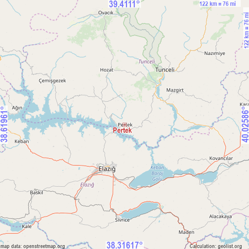
Pertek GPS coordinates[2]
38° 51' 56.664" North, 39° 19' 21.828" East
| Map corner | latitude | longitude |
|---|---|---|
| Upper-left | 39.4111°, | 38.61961° |
| Center: | 38.86574°, | 39.32273° |
| Lower-right: | 38.31617°, | 40.02586° |
| Map W x H: | 121.7×121.7 km | = 75.6×75.6mi |
| max Lat: | 42.02683° ⇑47.3% North |
| Pertek: | 38.86574° |
| min Lat: | ⇓52.7% South 35.9025° |
| min Long | Pertek | max Long |
| 25.90902° | 39.32273° | 44.60099° |
| W 70.1%⇐ | ⇒29.9% E |
Elevation
Elevation of Pertek is 1058 m = 3471 ft, and this is 340.6 m = 1117 ft above average elevation for this country.
| Max E: |
2682 m = 8799 ft | 27.9% |
| Pertek | 1058 m 3471 ft | |
| Avg. | 717.4 m = 2354 ft | |
Min E: |
0 m = 0 ft | 72.1% |
See also: Turkey elevation on elevation.city.
Geographical zone
Pertek is located in North temperate zone (between Tropic of Cancer and the Arctic Circle). Distance of this Northern Tropic circle is 1715.5 km =1066 mi to South.| Distance of | km | miles | from Pertek |
|---|---|---|---|
| North Pole | 5685.6 | 3532.9 | to North |
| Arctic Circle | 3079.7 | 1913.6 | to North |
| Tropic Cancer | 1715.5 | 1066 | to South |
| Equator | 4321.5 | 2685.3 | to South |


Nearby cities:
15 places around Pertek: (largest is in red/bold)
• Akpazar
30 km =18.6 mi,  94°
94°
• Dere
13.2 km =8.2 mi,  351°
351°
• Elazığ
23 km =14.3 mi,  202°
202°
• Harput
19.3 km =12 mi, 201°
• Hozat
27.9 km =17.3 mi,  339°
339°
• Hıdırbaba
31.9 km =19.8 mi,  249°
249°
• Mazgirt
29.4 km =18.3 mi,  54°
54°
• Mollakendi
32.1 km =19.9 mi,  178°
178°
• Poyraz
32.8 km =20.4 mi,  232°
232°
• Pınarlar
13 km =8.1 mi, 85°
• Tunceli
32.2 km =20 mi,  36°
36°
• Çaybağı
25.3 km =15.7 mi,  99°
99°
• Çaybağı
32.1 km =19.9 mi,  126°
126°
• Çağlarca
24.8 km =15.4 mi,  320°
320°
• Çiçekli
22.5 km =14 mi,  21°
21°
Sources, notices
• [Note1] Compared only with cities in Turkey existing in our database
• [Src1] Map data: © OpenStreetMap contributors (CC-BY-SA)
• [Src2] Other city data from geonames.org with taken over terms of usage.
• [Src3] Geographical zone / Annual Mean Temperature by Robert A. Rohde @ Wikipedia
