Çiçekli geodata
Çiçekli (Tunceli) is a seat of a third-order administrative division; located in Turkey in Europe/Istanbul (GMT+3) time zone. In our database, there are 1323 cities with bigger population. Compared to other cities in Turkey, 55.3% of cities are located further ↓South; 70.6% of cities are located further ←West and 75.9% of cities have lower elevation than Çiçekli. Note1


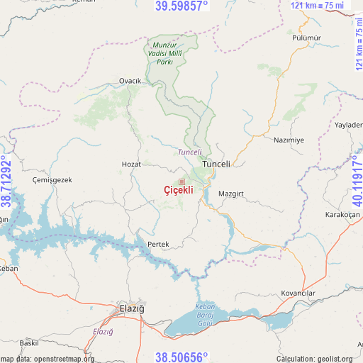
Çiçekli GPS coordinates[2]
39° 3' 16.848" North, 39° 24' 57.744" East
| Map corner | latitude | longitude |
|---|---|---|
| Upper-left | 39.59857°, | 38.71292° |
| Center: | 39.05468°, | 39.41604° |
| Lower-right: | 38.50656°, | 40.11917° |
| Map W x H: | 121.4×121.4 km | = 75.4×75.4mi |
| max Lat: | 42.02683° ⇑44.7% North |
| Çiçekli: | 39.05468° |
| min Lat: | ⇓55.3% South 35.9025° |
| min Long | Çiçekli | max Long |
| 25.90902° | 39.41604° | 44.60099° |
| W 70.6%⇐ | ⇒29.4% E |
Elevation
Elevation of Çiçekli is 1119 m = 3671 ft, and this is 401.6 m = 1318 ft above average elevation for this country.
| Max E: |
2682 m = 8799 ft | 24.1% |
| Çiçekli | 1119 m 3671 ft | |
| Avg. | 717.4 m = 2354 ft | |
Min E: |
0 m = 0 ft | 75.9% |
See also: Turkey elevation on elevation.city.
Geographical zone
Çiçekli is located in North temperate zone (between Tropic of Cancer and the Arctic Circle). Distance of this Northern Tropic circle is 1736.6 km =1079.1 mi to South.| Distance of | km | miles | from Çiçekli |
|---|---|---|---|
| North Pole | 5664.6 | 3519.8 | to North |
| Arctic Circle | 3058.7 | 1900.6 | to North |
| Tropic Cancer | 1736.6 | 1079.1 | to South |
| Equator | 4342.5 | 2698.3 | to South |


Nearby cities:
15 places around Çiçekli: (largest is in red/bold)
• Akpazar
31.8 km =19.8 mi,  136°
136°
• Darıkent
35.4 km =22 mi,  106°
106°
• Dere
12.8 km =8 mi,  231°
231°
• Hozat
18.6 km =11.6 mi,  285°
285°
• Karaoğlan
26.2 km =16.3 mi,  316°
316°
• Kocakoç
22.1 km =13.7 mi,  71°
71°
• Mazgirt
16.5 km =10.3 mi,  104°
104°
• Nazimiye
38.2 km =23.7 mi, 68°
• Ovacık
37.6 km =23.4 mi,  331°
331°
• Pertek
22.5 km =14 mi,  201°
201°
• Pınarlar
20.7 km =12.9 mi,  166°
166°
• Sütlüce
16.3 km =10.1 mi,  42°
42°
• Tunceli
12.1 km =7.5 mi, 65°
• Çaybağı
30.3 km =18.8 mi,  146°
146°
• Çağlarca
24 km =14.9 mi,  265°
265°
Sources, notices
• [Note1] Compared only with cities in Turkey existing in our database
• [Src1] Map data: © OpenStreetMap contributors (CC-BY-SA)
• [Src2] Other city data from geonames.org with taken over terms of usage.
• [Src3] Geographical zone / Annual Mean Temperature by Robert A. Rohde @ Wikipedia
