Palu geodata
Palu (Elazığ) is a seat of a second-order administrative division; located in Turkey in Europe/Istanbul (GMT+3) time zone. With population of 11,271 people, there are 472 cities with bigger population in this country. Compared to other cities in Turkey, 50% of cities are located further ↓South; 73.3% of cities are located further ←West and 60.4% of cities have lower elevation than Palu. Note1


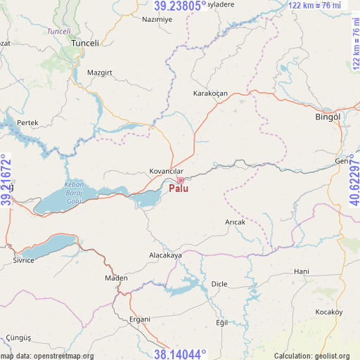
Palu GPS coordinates[2]
38° 41' 28.86" North, 39° 55' 11.424" East
| Map corner | latitude | longitude |
|---|---|---|
| Upper-left | 39.23805°, | 39.21672° |
| Center: | 38.69135°, | 39.91984° |
| Lower-right: | 38.14044°, | 40.62297° |
| Map W x H: | 122×122 km | = 75.8×75.8mi |
| max Lat: | 42.02683° ⇑50% North |
| Palu: | 38.69135° |
| min Lat: | ⇓50% South 35.9025° |
| min Long | Palu | max Long |
| 25.90902° | 39.91984° | 44.60099° |
| W 73.3%⇐ | ⇒26.7% E |
Elevation
Elevation of Palu is 889 m = 2917 ft, and this is 171.6 m = 563 ft above average elevation for this country.
| Max E: |
2682 m = 8799 ft | 39.6% |
| Palu | 889 m 2917 ft | |
| Avg. | 717.4 m = 2354 ft | |
Min E: |
0 m = 0 ft | 60.4% |
See also: Turkey elevation on elevation.city.
Geographical zone
Palu is located in North temperate zone (between Tropic of Cancer and the Arctic Circle). Distance of this Northern Tropic circle is 1696.2 km =1054 mi to South.| Distance of | km | miles | from Palu |
|---|---|---|---|
| North Pole | 5705 | 3544.9 | to North |
| Arctic Circle | 3099.1 | 1925.7 | to North |
| Tropic Cancer | 1696.2 | 1054 | to South |
| Equator | 4302.1 | 2673.2 | to South |


Nearby cities:
15 places around Palu: (largest is in red/bold)
• Akpazar
27.8 km =17.3 mi,  308°
308°
• Alacakaya
26.5 km =16.5 mi,  191°
191°
• Arıcak
22.8 km =14.2 mi,  128°
128°
• Başyurt
16.8 km =10.4 mi,  17°
17°
• Darıkent
31.7 km =19.7 mi,  342°
342°
• Dicle
38.3 km =23.8 mi,  160°
160°
• Gökdere
25.7 km =16 mi,  77°
77°
• Karakoçan
30.4 km =18.9 mi, 17°
• Kovancılar
5.8 km =3.6 mi,  301°
301°
• Maden
40.5 km =25.2 mi,  213°
213°
• Pınarlar
43.8 km =27.2 mi, 297°
• Servi
37.3 km =23.2 mi,  111°
111°
• Çaybağı
26 km =16.2 mi,  270°
270°
• Çaybağı
30.9 km =19.2 mi, 299°
• İçme
33.2 km =20.6 mi,  254°
254°
Sources, notices
• [Note1] Compared only with cities in Turkey existing in our database
• [Src1] Map data: © OpenStreetMap contributors (CC-BY-SA)
• [Src2] Other city data from geonames.org with taken over terms of usage.
• [Src3] Geographical zone / Annual Mean Temperature by Robert A. Rohde @ Wikipedia
