Arıcak geodata
Arıcak (Elazığ) is a seat of a second-order administrative division; located in Turkey in Europe/Istanbul (GMT+3) time zone. With population of 5,168 people, there are 705 cities with bigger population in this country. Compared to other cities in Turkey, 52.2% of cities are located further ↑North; 74.2% of cities are located further ←West and 75.6% of cities have lower elevation than Arıcak. Note1


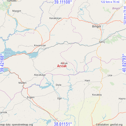
Arıcak GPS coordinates[2]
38° 33' 48.24" North, 40° 7' 29.28" East
| Map corner | latitude | longitude |
|---|---|---|
| Upper-left | 39.11108°, | 39.42168° |
| Center: | 38.5634°, | 40.1248° |
| Lower-right: | 38.01151°, | 40.82793° |
| Map W x H: | 122.3×122.3 km | = 76×76mi |
| max Lat: | 42.02683° ⇑52.2% North |
| Arıcak: | 38.5634° |
| min Lat: | ⇓47.8% South 35.9025° |
| min Long | Arıcak | max Long |
| 25.90902° | 40.1248° | 44.60099° |
| W 74.2%⇐ | ⇒25.8% E |
Elevation
Elevation of Arıcak is 1116 m = 3661 ft, and this is 398.6 m = 1308 ft above average elevation for this country.
| Max E: |
2682 m = 8799 ft | 24.4% |
| Arıcak | 1116 m 3661 ft | |
| Avg. | 717.4 m = 2354 ft | |
Min E: |
0 m = 0 ft | 75.6% |
See also: Turkey elevation on elevation.city.
Geographical zone
Arıcak is located in North temperate zone (between Tropic of Cancer and the Arctic Circle). Distance of this Northern Tropic circle is 1681.9 km =1045.1 mi to South.| Distance of | km | miles | from Arıcak |
|---|---|---|---|
| North Pole | 5719.2 | 3553.7 | to North |
| Arctic Circle | 3113.3 | 1934.5 | to North |
| Tropic Cancer | 1681.9 | 1045.1 | to South |
| Equator | 4287.8 | 2664.3 | to South |


Nearby cities:
15 places around Arıcak: (largest is in red/bold)
• Alacakaya
25.9 km =16.1 mi,  242°
242°
• Başyurt
32.7 km =20.3 mi,  337°
337°
• Dicle
22.6 km =14 mi,  193°
193°
• Eğil
34.3 km =21.3 mi, 187°
• Genç
42.5 km =26.4 mi,  61°
61°
• Gökdere
21.2 km =13.2 mi,  19°
19°
• Hani
28.6 km =17.8 mi,  127°
127°
• Karakoçan
44 km =27.3 mi,  348°
348°
• Kocaköy
44.6 km =27.7 mi, 133°
• Kovancılar
28.6 km =17.8 mi,  307°
307°
• Maden
44.7 km =27.8 mi, 243°
• Palu
22.8 km =14.2 mi, 308°
• Servi
17 km =10.6 mi,  87°
87°
• Yamaç
36.1 km =22.4 mi,  49°
49°
• Yayla
35.8 km =22.2 mi,  77°
77°
Sources, notices
• [Note1] Compared only with cities in Turkey existing in our database
• [Src1] Map data: © OpenStreetMap contributors (CC-BY-SA)
• [Src2] Other city data from geonames.org with taken over terms of usage.
• [Src3] Geographical zone / Annual Mean Temperature by Robert A. Rohde @ Wikipedia
