Oymataş geodata
Oymataş (Batman) is a populated place; located in Turkey in Europe/Istanbul (GMT+3) time zone. With population of 1,907 people, there are 968 cities with bigger population in this country. Compared to other cities in Turkey, 68.6% of cities are located further ↑North; 81.6% of cities are located further ←West and 59.3% of cities have higher elevation than Oymataş. Note1


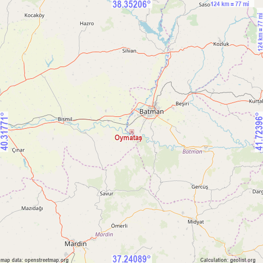
Oymataş GPS coordinates[2]
37° 47' 54.816" North, 41° 1' 14.988" East
| Map corner | latitude | longitude |
|---|---|---|
| Upper-left | 38.35206°, | 40.31771° |
| Center: | 37.79856°, | 41.02083° |
| Lower-right: | 37.24089°, | 41.72396° |
| Map W x H: | 123.6×123.6 km | = 76.8×76.8mi |
| max Lat: | 42.02683° ⇑68.6% North |
| Oymataş: | 37.79856° |
| min Lat: | ⇓31.4% South 35.9025° |
| min Long | Oymataş | max Long |
| 25.90902° | 41.02083° | 44.60099° |
| W 81.6%⇐ | ⇒18.4% E |
Elevation
Elevation of Oymataş is 518 m = 1699 ft, and this is 199.4 m = 654 ft below average elevation for this country.
| Max E: |
2682 m = 8799 ft | 59.3% |
| Avg. | 717.4 m = 2354 ft | |
| Oymataş | 518 m = 1699 ft | |
Min E: |
0 m = 0 ft | 40.7% |
See also: Turkey elevation on elevation.city.
Geographical zone
Oymataş is located in North temperate zone (between Tropic of Cancer and the Arctic Circle). Distance of this Northern Tropic circle is 1596.9 km =992.3 mi to South.| Distance of | km | miles | from Oymataş |
|---|---|---|---|
| North Pole | 5804.3 | 3606.6 | to North |
| Arctic Circle | 3198.4 | 1987.4 | to North |
| Tropic Cancer | 1596.9 | 992.3 | to South |
| Equator | 4202.8 | 2611.5 | to South |


Nearby cities:
15 places around Oymataş: (largest is in red/bold)
• Akça
15.5 km =9.6 mi,  66°
66°
• Bademli
15.1 km =9.4 mi,  339°
339°
• Balpınar
8.3 km =5.2 mi,  21°
21°
• Batman
13.9 km =8.6 mi,  44°
44°
• Başhan
14.6 km =9.1 mi,  220°
220°
• Diktepe
13.9 km =8.6 mi,  14°
14°
• Erköklü
12.9 km =8 mi,  56°
56°
• Evkuran
16.2 km =10.1 mi,  197°
197°
• Güngeçti
15 km =9.3 mi,  321°
321°
• Harmantepe
10.8 km =6.7 mi,  186°
186°
• Karayün
9.1 km =5.7 mi, 63°
• Salat
12.7 km =7.9 mi,  292°
292°
• Sinanköy
7.4 km =4.6 mi, 340°
• Yeniköy
9.5 km =5.9 mi, 15°
• İkiztepe
11.9 km =7.4 mi,  28°
28°
Sources, notices
• [Note1] Compared only with cities in Turkey existing in our database
• [Src1] Map data: © OpenStreetMap contributors (CC-BY-SA)
• [Src2] Other city data from geonames.org with taken over terms of usage.
• [Src3] Geographical zone / Annual Mean Temperature by Robert A. Rohde @ Wikipedia
