Harmantepe geodata
Harmantepe (Mardin) is a populated place; located in Turkey in Europe/Istanbul (GMT+3) time zone. With population of 505 people, there are 1313 cities with bigger population in this country. Compared to other cities in Turkey, 70.6% of cities are located further ↑North; 81.5% of cities are located further ←West and 52.5% of cities have lower elevation than Harmantepe. Note1


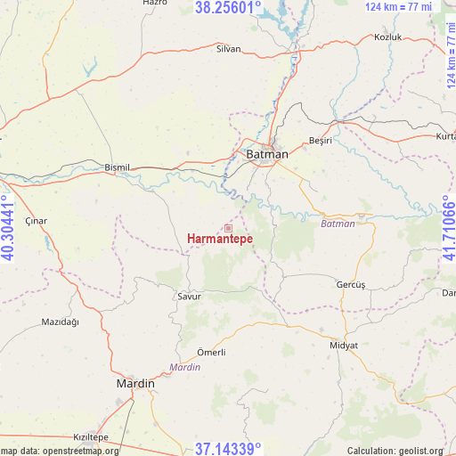
Harmantepe GPS coordinates[2]
37° 42' 6.444" North, 41° 0' 27.108" East
| Map corner | latitude | longitude |
|---|---|---|
| Upper-left | 38.25601°, | 40.30441° |
| Center: | 37.70179°, | 41.00753° |
| Lower-right: | 37.14339°, | 41.71066° |
| Map W x H: | 123.7×123.7 km | = 76.9×76.9mi |
| max Lat: | 42.02683° ⇑70.6% North |
| Harmantepe: | 37.70179° |
| min Lat: | ⇓29.4% South 35.9025° |
| min Long | Harmantepe | max Long |
| 25.90902° | 41.00753° | 44.60099° |
| W 81.5%⇐ | ⇒18.5% E |
Elevation
Elevation of Harmantepe is 750 m = 2461 ft, and this is 32.6 m = 107 ft above average elevation for this country.
| Max E: |
2682 m = 8799 ft | 47.5% |
| Harmantepe | 750 m 2461 ft | |
| Avg. | 717.4 m = 2354 ft | |
Min E: |
0 m = 0 ft | 52.5% |
See also: Turkey elevation on elevation.city.
Geographical zone
Harmantepe is located in North temperate zone (between Tropic of Cancer and the Arctic Circle). Distance of this Northern Tropic circle is 1586.1 km =985.6 mi to South.| Distance of | km | miles | from Harmantepe |
|---|---|---|---|
| North Pole | 5815 | 3613.3 | to North |
| Arctic Circle | 3209.1 | 1994 | to North |
| Tropic Cancer | 1586.1 | 985.6 | to South |
| Equator | 4192 | 2604.8 | to South |


Nearby cities:
15 places around Harmantepe: (largest is in red/bold)
• Balpınar
19 km =11.8 mi,  12°
12°
• Başhan
8.4 km =5.2 mi,  267°
267°
• Başkavak
18.5 km =11.5 mi,  214°
214°
• Doruk
18.9 km =11.7 mi, 270°
• Evkuran
6 km =3.7 mi,  219°
219°
• Harmanlı
15.9 km =9.9 mi,  280°
280°
• Karayün
17.5 km =10.9 mi,  32°
32°
• Kayapınar
21 km =13 mi,  139°
139°
• Oymataş
10.8 km =6.7 mi, 6°
• Salat
18.8 km =11.7 mi,  325°
325°
• Sinanköy
17.8 km =11.1 mi,  355°
355°
• Soylu
17.8 km =11.1 mi,  251°
251°
• Teffi
17.8 km =11.1 mi,  154°
154°
• Tokluca
13.3 km =8.3 mi,  168°
168°
• Yeniköy
20.2 km =12.6 mi, 10°
Sources, notices
• [Note1] Compared only with cities in Turkey existing in our database
• [Src1] Map data: © OpenStreetMap contributors (CC-BY-SA)
• [Src2] Other city data from geonames.org with taken over terms of usage.
• [Src3] Geographical zone / Annual Mean Temperature by Robert A. Rohde @ Wikipedia
