Elmalıdere geodata
Elmalıdere (Erzurum) is a seat of a third-order administrative division; located in Turkey in Europe/Istanbul (GMT+3) time zone. In our database, there are 1323 cities with bigger population. Compared to other cities in Turkey, 63.5% of cities are located further ↓South; 92.9% of cities are located further ←West and 99% of cities have lower elevation than Elmalıdere. Note1


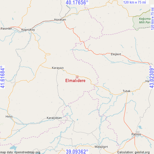
Elmalıdere GPS coordinates[2]
39° 38' 13.956" North, 42° 19' 11.856" East
| Map corner | latitude | longitude |
|---|---|---|
| Upper-left | 40.17656°, | 41.61684° |
| Center: | 39.63721°, | 42.31996° |
| Lower-right: | 39.09362°, | 43.02309° |
| Map W x H: | 120.4×120.4 km | = 74.8×74.8mi |
| max Lat: | 42.02683° ⇑36.5% North |
| Elmalıdere: | 39.63721° |
| min Lat: | ⇓63.5% South 35.9025° |
| min Long | Elmalıdere | max Long |
| 25.90902° | 42.31996° | 44.60099° |
| W 92.9%⇐ | ⇒7.1% E |
Elevation
Elevation of Elmalıdere is 2023 m = 6637 ft, and this is 1305.6 m = 4283 ft above average elevation for this country.
| Max E: |
2682 m = 8799 ft | 1% |
| Elmalıdere | 2023 m 6637 ft | |
| Avg. | 717.4 m = 2354 ft | |
Min E: |
0 m = 0 ft | 99% |
See also: Turkey elevation on elevation.city.
Geographical zone
Elmalıdere is located in North temperate zone (between Tropic of Cancer and the Arctic Circle). Distance of this Northern Tropic circle is 1801.3 km =1119.3 mi to South.| Distance of | km | miles | from Elmalıdere |
|---|---|---|---|
| North Pole | 5599.8 | 3479.6 | to North |
| Arctic Circle | 2993.9 | 1860.3 | to North |
| Tropic Cancer | 1801.3 | 1119.3 | to South |
| Equator | 4407.2 | 2738.5 | to South |


Nearby cities:
15 places around Elmalıdere: (largest is in red/bold)
• Aktuzla
34.3 km =21.3 mi,  184°
184°
• Aras
39 km =24.2 mi,  358°
358°
• Eleşkirt
35.3 km =21.9 mi,  59°
59°
• Göksu
21.9 km =13.6 mi,  221°
221°
• Horasan
46.6 km =29 mi,  343°
343°
• Karaköprü
47 km =29.2 mi, 220°
• Karayazı
16.5 km =10.3 mi,  293°
293°
• Karaçoban
37.7 km =23.4 mi,  210°
210°
• Köprüköy
53.1 km =33 mi,  313°
313°
• Nurettin
42.7 km =26.5 mi,  157°
157°
• Nurettin
46.2 km =28.7 mi,  169°
169°
• Söylemez
46.4 km =28.8 mi, 287°
• Tahir
26 km =16.2 mi,  20°
20°
• Tutak
39.8 km =24.7 mi,  106°
106°
• Çiftlik
48.7 km =30.3 mi,  353°
353°
Sources, notices
• [Note1] Compared only with cities in Turkey existing in our database
• [Src1] Map data: © OpenStreetMap contributors (CC-BY-SA)
• [Src2] Other city data from geonames.org with taken over terms of usage.
• [Src3] Geographical zone / Annual Mean Temperature by Robert A. Rohde @ Wikipedia
